分类: environment

  • Two Tropical Waves Being Monitored in Atlantic as Development Chances Rise

    Two Tropical Waves Being Monitored in Atlantic as Development Chances Rise

    As the 2026 Atlantic hurricane season enters its most active period, the U.S. National Hurricane Center has placed two emerging tropical waves across the Atlantic basin under constant surveillance, with meteorologists projecting low but non-negligible chances of cyclone development over the coming seven days.

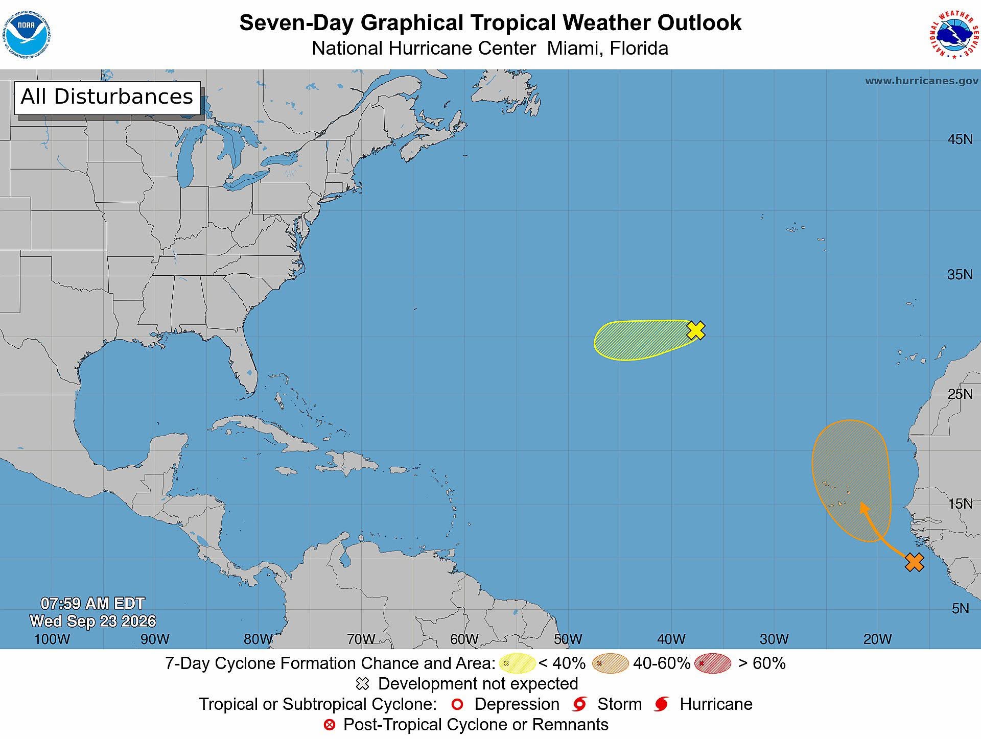
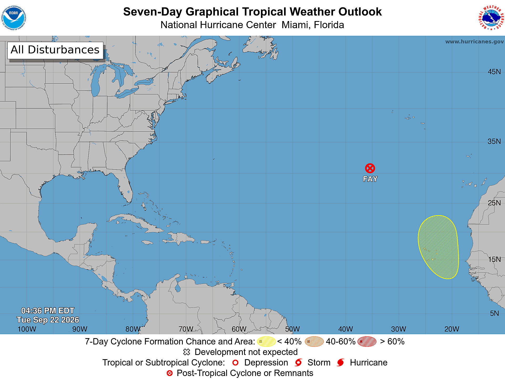
    As of 2 p.m. Eastern Daylight Time on Saturday, August 8, the first of the two disturbances, located across the central tropical Atlantic, is not expected to strengthen into a named tropical cyclone within the next two days, with official forecasts placing its 48-hour formation probability at nearly zero. Over a longer seven-day window, however, that chance rises to 20%. Forecasters note that slow, incremental strengthening of this system could occur as the week progresses, between the early and middle stages of the coming week.

    A second tropical wave, spanning the eastern and central sections of the tropical Atlantic, is also being tracked closely by forecasters. Like the first system, it carries a near-zero chance of cyclone formation in the next 48 hours. Unlike its counterpart, though, its seven-day formation likelihood has been upgraded to 30%, a small but notable increase from earlier projections. Gradual strengthening of this second system is forecast to become possible between the middle and end of next week, should conditions align for development.

    Neither disturbance is projected to undergo immediate cyclone development at this time, but continuous monitoring remains in place as both systems traverse the tropical Atlantic during the peak of the 2026 season. Climatologically, August kicks off a sharp uptick in tropical cyclone activity across the basin, with the seasonal historical peak for storm formation falling in mid-September. The official Atlantic hurricane season runs annually from June 1 through November 30, covering the full window when conditions are most favorable for tropical storm and hurricane development.

    Local authorities are urging residents of Antigua and Barbuda, as well as communities across the rest of the Lesser Antilles, to stay updated on evolving conditions by checking official forecasts and regular bulletins released by the Antigua and Barbuda Meteorological Service as the two systems continue their westward movement across the Atlantic.

  • What’s Behind the Fish Kill in the Belize River? Public Advisory ‘Still in Effect’

    What’s Behind the Fish Kill in the Belize River? Public Advisory ‘Still in Effect’

    In a developing environmental emergency along Belize’s major waterway, officials have confirmed that a 17.5-mile stretch of the Belize River is grappling with severely depleted dissolved oxygen levels, the primary observed condition linked to a widespread mass fish mortality event first reported earlier this week.

    As of the latest official update released Friday by Belize’s Department of the Environment (DOE), investigators have not yet identified the root cause of the die-off or pinpointed any party responsible for the contamination or conditions that triggered the event. The assessment area stretches from the vicinity of Banana Bank, located upstream of Santander Farms, all the way to the Burrell Boom Village bridge. Field teams recorded the most severe fish deaths and most dramatic shifts in water quality between the Isabella Bank and Grace Bank segments of the river.

    Preliminary on-site testing uncovered additional worrying water conditions at multiple monitoring points: elevated conductivity, increased chlorophyll-a concentrations, and higher turbidity than normal. All of these factors are known to create hostile environments for native aquatic life, according to the DOE. To pinpoint the exact causes of the event, investigators have collected a range of samples for detailed laboratory analysis, including water samples from the Santander Farms drainage network and multiple downstream sites, as well as tissue samples from deceased fish and sediment samples from the affected stretch. These samples will be tested to confirm whether any man-made contaminants played a role in the mass die-off. Department officials are also reviewing high-resolution satellite imagery to identify other potential contributing factors that may not be visible through ground-based assessments alone.

    A public health precautionary advisory first issued Wednesday remains fully in effect for all communities along the affected river segment. The advisory urges residents and visitors to avoid eating fish or any other aquatic resources harvested from the impacted area, and to refrain from using untreated river water for drinking, cooking, food preparation, or providing water for livestock and domestic pets.

    In its own public statement released Friday, Santander Sugar Group, the agricultural operator that owns Santander Farms in the upstream area, said it has granted DOE investigators full, unrestricted access to all of its facilities and on-site operations to support the ongoing probe. The company pushed back against any implied connection to the fish kill, noting that its sugar processing factory operates a closed-loop water management system that does not allow for routine discharge of high-temperature process water into the Belize River. It also confirmed that its on-site irrigation and processing canals are not connected to Labouring Creek, a tributary that feeds into the impacted main stem of the Belize. Per Santander Sugar Group’s explanation, all process water generated at the facility is recovered, actively managed, cooled when required, and reused within the factory’s operations, with no regular discharge into surrounding waterways.

  • Two tropical waves under observation as the Atlantic begins to heat up

    Two tropical waves under observation as the Atlantic begins to heat up

    As August ushers in the most dangerous phase of the annual Atlantic hurricane cycle, the top official of the Dominican Republic’s national meteorological agency has sounded a public alert over rising storm activity in the basin, alongside ongoing impacts from transcontinental dust transport shaping local weather this weekend.

    Gloria Ceballos, director of the Dominican Institute of Meteorology (Indomet), shared the update Saturday, noting that the Atlantic basin is showing early signs of increased storm formation just as the season enters its historically most active window. “It’s August, we’re stepping into the peak of the hurricane season, and the Atlantic is beginning to stir,” Ceballos stated, referencing two tropical waves that Indomet’s forecasting teams have been tracking closely for potential development into cyclonic systems over the coming week.

    Ceballos emphasized that right now, both monitored systems carry only a low probability of consolidating into named storms or hurricanes. As the systems drift westward toward the Caribbean basin, they are expected to encounter atmospheric and oceanic conditions that are hostile to cyclonic growth. Still, the agency has committed to continuous monitoring to update the public on any changes in trajectory or intensity. “We will follow their evolution step by step, even if current conditions do not favor development,” Ceballos added.

    Beyond the long-term monitoring of tropical systems, Indomet also released its on-the-ground weather forecast for Dominican territory this Saturday, noting that the country remains under the blanket of a denser-than-usual plume of Saharan dust. This airborne dust layer has suppressed large-scale cloud formation, preventing the build-up of significant moisture that would lead to heavy, widespread rainfall across most of the country.

    The forecast calls for minimal precipitation and sweltering high temperatures across the majority of the Dominican Republic for the day. Even so, Indomet did not rule out isolated, short-lived weather events through the afternoon and early evening. A combination of persistent easterly trade winds, daytime surface heating, and the region’s mountainous topography could trigger localized increases in cloud cover.

    Those conditions are expected to produce scattered, short downpours and isolated thunderstorms primarily across the central and northwestern regions of the country, including the provinces of Monte Plata, Santo Domingo Norte, La Vega, Monseñor Nouel, San Cristóbal, Sánchez Ramírez, San Juan, Elías Piña, and Dajabón, as well as adjacent surrounding areas.

  • Tropical Wave Given 20% Chance of Development as Atlantic Approaches Peak of Hurricane Season

    Tropical Wave Given 20% Chance of Development as Atlantic Approaches Peak of Hurricane Season

    As the Atlantic basin approaches the historical peak of annual hurricane activity, the U.S. National Hurricane Center (NHC) is tracking a newly identified tropical system with a low probability of strengthening into a cyclone over the coming week. The weather disturbance, a tropical wave, is projected to exit the western coast of Africa next Tuesday, and forecasters say gradual development could occur as it drifts westward across the eastern and central portions of the tropical Atlantic through the second half of next week.

    Per the NHC’s Saturday morning update, the system carries a near-zero chance of cyclone formation within the 48-hour window starting Saturday, with that probability climbing only to 20% across the full seven-day forecast period. At present, the disturbance is located thousands of miles east of the Caribbean Sea, and the agency has confirmed that it does not currently pose any risk to inhabited landmasses across the basin.

    This new system of interest emerges against the backdrop of an exceptionally slow start to the 2026 Atlantic hurricane season. Earlier this week, the NHC reported that overall tropical cyclone activity has remained unusually muted as the season enters August. The Accumulated Cyclone Energy (ACE) index, a key metric that accounts for both the intensity and duration of all tropical storms and hurricanes in a season, is currently running roughly 75% below the long-term average for this point in the year.

    Officially, the Atlantic hurricane season runs from June 1 through November 30 annually, but decades of meteorological data show the vast majority of storm activity occurs between the August to October window, aligned with the formation conditions for tropical systems. This new monitoring effort also comes after the U.S. National Oceanic and Atmospheric Administration (NOAA) downgraded its activity forecast for the remainder of the 2026 season.

    NOAA now projects a 75% probability that the full 2026 season will end with below-normal activity. Its updated outlook calls for a total of 7 to 13 named storms across the basin, of which 2 to 6 are expected to strengthen into hurricanes. Forecasters further predict that between zero and 2 of those storms will intensify into major hurricanes, ranked Category 3 or higher on the Saffir-Simpson scale.

    This revised forecast represents a marked downward adjustment from projections released before the season began, and reflects current atmospheric and oceanic conditions that have proven broadly unfavorable for tropical cyclone development across the Atlantic so far this year. Even with the muted overall outlook, meteorologists emphasize the most active period of the hurricane season still lies ahead. Atlantic storm activity historically surges through August and September, as tropical waves regularly move off the African coast and traverse the warm waters of the tropical Atlantic where conditions can allow for rapid strengthening.

    As of the NHC’s Saturday update, there are currently no active tropical cyclones anywhere across the entire Atlantic basin.

  • DNA dringt aan op duidelijkheid over oorzaak massale vissterfte

    DNA dringt aan op duidelijkheid over oorzaak massale vissterfte

    In the wake of a mass fish mortality event along Suriname’s Saramacca River that has sparked public and legislative concern, authorities are still working to pinpoint a definitive cause, according to the country’s Minister of Oil, Gas and the Environment Patrick Brunings.

    Addressing questions from members of the National Assembly on Thursday, Brunings confirmed that final research results are still pending, with additional environmental data currently being collected to clarify what led to the large-scale die-off. Lawmakers have pressed for urgent clarity on potential pollution sources, active industrial operators in the affected river basin, and concrete policies to prevent a repeat of the environmental disaster.

    Brunings defended the government’s rapid response in the immediate aftermath of the fish deaths, noting that a dedicated response team was deployed immediately to collect water and tissue samples that form the core of the ongoing investigation. All collected data is currently undergoing comprehensive analysis, and full findings will be shared publicly once finalized, Brunings said. These results will also guide the development of long-term action plans to address environmental risks in the region.

    The minister added that the ministry is currently compiling a complete public register of all concession holders and operating companies along the Saramacca River. Information from past inspections conducted by the National Environmental Authority, as well as the full list of regulatory requirements companies must meet to hold river-area concessions, will be shared with the National Assembly in the coming weeks.

    In a key announcement, Brunings confirmed the government will partner with the Ministry of Public Health and the Pan American Health Organization (PAHO) to conduct a wide-ranging biomedical study of communities living in affected areas along Suriname’s river systems. The research will not be limited to the location of the recent mass fish deaths, and will focus on detecting potential long-term exposure to harmful chemicals and mercury among local residents. The collected data will serve as a baseline reference for long-term monitoring of public health trends across the region.

    Brunings also provided an update on separate ongoing research into mercury vapor emissions linked to artisanal and small-scale gold mining. An initial round of testing, focused primarily at gold purchasing facilities, has already been completed. A second round of more advanced testing required specialized equipment that was sent to Canada for calibration, which has now been returned to Suriname. The new round of testing will cover gold buying operations and other sites across the country where harmful emissions are suspected to occur.

    Lawmakers across the National Assembly have repeatedly emphasized that significant gaps in transparency remain around the fish mortality event. Members have called for full disclosure of which companies and individuals hold concessions in the area under investigation, referencing recent comments from President Jennifer Simons that pointed to potential links to activities within a concession held by mining firm Grassalco. Legislators have pushed for details on the exact boundaries of active concessions, the legal status of ongoing operations, and whether any formal prevention plan has been put in place to stop future environmental disasters.

    During Thursday’s debate, assembly members highlighted that even as the investigation into the Saramacca River event progresses, unregulated use of toxic chemicals in mining operations continues in other inland areas of Suriname. They have demanded the government outline immediate short-term measures to prevent a similar incident from occurring elsewhere.

    The debate also covered Suriname’s current rules around the import and use of mercury, cyanide, and other toxic chemicals common in gold mining. Lawmakers have repeatedly called for stricter regulatory oversight, better industry governance, and a long-term structural overhaul of the gold sector, warning that waiting for another environmental catastrophe to act is unacceptable. Members also asked for clarification on the role of the Ministry of Oil, Gas and the Environment in reviewing permit applications for mining operations and gold purchasing facilities.

    Assembly members have framed the Saramacca River mass fish death event as a critical wake-up call to strengthen enforcement of mining rules, crack down on unauthorized chemical use, and improve compliance with national environmental regulations. Beyond regulatory reform, they have called on the government to immediately outline short-term protective measures for inland communities that rely on Suriname’s river systems for food and livelihoods.

  • They carry out a reforestation and cleaning day in river basins in Cotuí

    They carry out a reforestation and cleaning day in river basins in Cotuí

    In a collaborative push to strengthen environmental conservation and protect critical water resources, Dominican Republic’s Ministry of Energy and Mines has led a large-scale reforestation and tributary cleanup day in the Hatillo community of Cotuí, located in Sánchez Ramírez province. The initiative brought together dozens of partners from multiple state agencies and a major local mining operator to restore ecologically vital river basins that support regional water security.

    Over 70 participants from the Ministry of Environment and Natural Resources, the National Environmental Protection Service (Senpa), and Barrick Pueblo Viejo joined the event, planting a total of 240 native seedlings across the Colorao, Zinc, and Margajita river basins. The selected species—220 cedar, mahogany, and Juan Primero seedlings plus 20 bamboo plants—were chosen to match the local ecosystem’s needs, and were placed approximately five meters from riverbanks to maximize soil stabilization and water protection. Beyond tree planting, volunteers collected accumulated plastic waste from the tributaries to reduce water pollution and preserve aquatic habitats.

    Speaking on behalf of Energy and Mines Minister Joel Santos, Vice Minister of Mines Giovanni Bloise emphasized that environmental stewardship is a top national priority for the Dominican Republic, an island nation entirely dependent on internal freshwater production. “The environmental issue is vital for the Dominican Republic, because we are an island and we must produce water within our own territory,” Bloise noted. He also pushed back against the misconception that mining development and ecological protection are incompatible, arguing that well-regulated, responsible mining operations can actually enhance environmental value rather than detract from it. “The environment and supervised, responsible mining activity are perfectly compatible; and instead of detracting from its value, it actually adds to it,” he stated.

    This river basin project is just one part of the Ministry of Energy and Mines’ ongoing series of national environmental initiatives. In addition to large-scale reforestation work across the country, the institution runs community crop and reforestation programs in Sánchez Ramírez that plant food crops including beans, cassava, sweet potatoes, avocados, and plantains. Omar Dotel, Director of Environmental and Social Affairs at the ministry, highlighted that the organization has already delivered successful ecological restoration at previously damaged sites, including the Mejita dam, where a former environmental liability area has been transformed into a thriving fully recovered forest.

    Dotel added that these collaborative community events deliver long-term value beyond immediate ecological gains, building environmental awareness among participants at low cost while leaving a lasting positive legacy for coming generations.

    Regional environmental leaders and private sector partners have praised the initiative as a model for cross-sector cooperation. Franklin Bautista, provincial director of the Ministry of Environment and Natural Resources in Sánchez Ramírez, thanked the Ministry of Energy and Mines for advancing projects that strike a critical balance between productive mining activity and ecological protection in the region’s mining district. Jahaziel Serrano, Superintendent of Social Responsibility at Barrick Pueblo Viejo, echoed that sentiment, reaffirming the private sector’s commitment to collective natural resource conservation. Serrano emphasized that a sustained focus on sustainability allows for responsible resource management today while securing a healthier future for generations to come.

    Senior leadership from across participating institutions attended the event, including Director of Mining Promotion Golye Latoufe, Senpa provincial head Major Leonardo Rodríguez, and Ministry of Energy and Mines provincial technical sub-director José Ramón Gómez, among others.

  • Sweltering weekend: extreme heat and Saharan dust

    Sweltering weekend: extreme heat and Saharan dust

    As the weekend approaches, the Dominican Republic is bracing for a stretch of oppressive heat paired with erratic weather patterns driven by tropical systems and atmospheric activity, according to official weather forecasts. The unseasonably warm conditions kicked off on Friday, with most areas starting the day under bright, mostly clear skies that quickly gave way to building cloud cover through the afternoon and early evening. Forecasters have warned of isolated showers and thunderstorms expected to form across a swath of inland and coastal provinces, including Monte Plata, San Cristóbal, San Pedro de Macorís, San José de Ocoa, Monseñor Nouel, Samaná, Azua, San Juan, Elías Piña, and multiple districts of Greater Santo Domingo.

    Across the majority of the country, daily high temperatures are projected to climb into a sweltering range between 33°C and 35°C, while overnight lows will stay mild, hovering between 23°C and 25°C – keeping overnight conditions uncomfortable even after sunset.

    Moving into Saturday, the first of two scheduled tropical waves will trigger scattered morning showers along the island nation’s northeast and southeast coastlines. But a counteracting air mass carrying elevated concentrations of Saharan dust will work to suppress atmospheric moisture and cut down on potential rainfall across most inland areas. As a result, only limited scattered showers and isolated thunderstorms are forecast for Saturday, concentrated in Monte Plata, Monseñor Nouel, San Cristóbal, Sánchez Ramírez, La Vega, San Juan, and sections of northern Santo Domingo.

    Sunday will bring a second, more active tropical wave, which when combined with elevated humidity levels and a deep upper-level trough, will produce more widespread precipitation. Forecasters are calling for scattered, locally moderate to heavy downpours across large portions of the country, paired with thunderstorms and sudden gusty winds. The worst of these conditions are expected to impact southeastern provinces – including the heavily populated Greater Santo Domingo area – as well as the northeast coast, the Central Mountain Range, and the country’s western border region, with peak activity forecast for the afternoon and evening hours.

    Public health and safety officials have issued a series of guidance to help residents cope with the dangerous heat. They advise all residents to maintain steady hydration, avoid extended periods of direct sun exposure between the peak heating hours of 11:00 a.m. and 4:00 p.m., and wear loose, light-colored lightweight clothing to help regulate body temperature. Extra precautions are urged for vulnerable groups including young children, pregnant people, elderly residents, and individuals living with chronic underlying health conditions, who face higher risk of heat-related illness.

    Additional hazards are forecast for coastal areas: starting Saturday, the Dominican Republic’s Caribbean coast will see increasingly rough surf conditions, with the most severe conditions expected along the shoreline from Pedernales to Barahona.

  • River Valley Residents Demand Answers on Sudden Fish Kill

    River Valley Residents Demand Answers on Sudden Fish Kill

    In the quiet Belize River Valley that has long sustained local communities, a sudden and unexplained mass fish death event has upended daily life, leaving residents demanding answers and prompting urgent government investigation. The event, which unfolded earlier this week, left dozens of dead fish bobbing along riverbanks, forcing authorities to issue an immediate warning barring public contact with aquatic life from the impacted stretch of water. As of August 6, 2026, the core cause of the die-off remains unconfirmed, though early preliminary data points to critically low dissolved oxygen levels in the affected water. For generations, communities along the Belize River have relied on the waterway for fishing, domestic use, and livelihood, turning this environmental disturbance into a pressing public concern that goes far beyond the dead fish washing ashore. Local resident Sharon Robinson, who lives in the community of Flowers Bank, drew a parallel to a similar die-off that hit the region roughly a decade ago, when a mass mortality event wiped out local lobster populations that have only recently started to recover. She suspects the source of the current contamination is located upstream on the Cayo side of the river, with pollutants carried downstream to the valley’s waters. A multi-agency investigation team, assembled in response to the incident, has already begun collecting water samples and mapping potential sources of pollution across the watershed, but investigators have yet to reach a definitive conclusion on what triggered the die-off. Ecologist Dr. Colin Young laid out one of the leading potential explanations for the oxygen depletion that has been tied to the fish kill. He noted that the region has recently seen heavy rainfall, which increases agricultural runoff carrying large volumes of sediment as well as nitrogen-based fertilizers from nearby farms into the river. When these nutrients and sediment enter the waterway, they fuel rapid, unchecked growth of algae and bacteria, which in turn consume most of the available dissolved oxygen in the water — creating hypoxic conditions that fish cannot survive in. Dr. Young added that the problem is not limited to this single event; for years, unregulated canal digging in the watershed has routinely deposited excess sediment, fertilizers, and other pollutants into the Belize River, creating a cumulative risk of harmful ecological events. He emphasized that slower, deeper, wider stretches of the river are particularly prone to trapping these pollutants, allowing oxygen levels to drop to lethal levels for aquatic life, even if the source of contamination is located much farther upstream. Currently, the Belize Department of the Environment (DOE) has maintained its strict safety advisory for residents: no consumption of fish or other aquatic life from impacted areas, no use of untreated river water for drinking, cooking, or watering livestock. The DOE has confirmed that the majority of local households receive safe treated water from Belize Water Services Limited (BWSL), but a significant number of residents still rely directly on the river for daily needs, making the warning a critical priority for public safety. Isabella Bank resident Francisca Madril shared the widespread community anxiety over the incident, saying she remains deeply concerned about the impact of the dead fish and contaminated water. Despite the uncertainty surrounding the cause and long-term impacts, many residents have reported early signs of improvement in recent days: water clarity has increased from the dark, murky conditions seen earlier in the week, and far fewer dead fish are seen floating downstream. That small improvement has not quelled resident concerns, however. Robinson explained that even with current low water levels, rising tides could carry contaminated water into residential yards, threatening backyard gardens and livestock that many families depend on. Dr. Young argued that while Belize already has strong environmental protection laws on the books to prevent unregulated sediment runoff and pollution, consistent enforcement has been lacking, allowing risky development and agricultural practices to continue unchecked. Development should not come at the cost of the river ecosystem that supports local communities, he emphasized. Now, residents across the Belize River Valley are calling for a full, transparent public investigation into the fish kill, and are demanding accountability for any parties found responsible for illegal pollution that contributed to the event. As investigators continue their work, the community remains on edge, waiting for confirmation of when their lifeline river will be safe to use again.

  • Hoe Gambiaanse vrouwen de mangroves herstellen die Banjul beschermen

    Hoe Gambiaanse vrouwen de mangroves herstellen die Banjul beschermen

    Before the midday sun scorches Gambia’s Atlantic coast, 34-year-old Fatou Jarjue waits for the tide to pull back from the Tanbi Wetlands. Pulling on thick gloves and sturdy socks, she pushes her hand-carved wooden canoe through narrow channels tangled with the sprawling, exposed roots of mangrove trees. Today, the empty pans stowed in her vessel are not meant for oysters—they will hold crabs that burrow in the wet mud beneath the water’s surface, as oyster harvesting is closed for the annual rainy season.

    For Jarjue, a mother of one, life is inextricably tied to this vast coastal wetland. Salt-tolerant mangroves, which naturally anchor shorelines and buffer communities from erosion and storm surge, have provided for her family for generations: the trees host oysters, crabs, and fish that feed her household and generate her income, while their dense root systems act as a natural sea wall for her coastal community. On most days, her brother Musa follows in a smaller canoe to keep watch as she paddles deeper into the mangrove forest; on other days, she navigates the muddy waterways alone.

    For generations, women in communities surrounding Tanbi Wetland have drawn their livelihood from these waters, and Jarjue continues that tradition. But unlike her predecessors, she has dedicated a large portion of her time to restoring the ecosystem that sustains her people. Just over one year since she began her restoration work, Jarjue says she has planted and restored more than 5,000 mangrove trees, reviving critical habitat that protects both the coast and the local fishing economy.

    Raised in Ndangan, a small settlement of 300 people just two kilometers from Banjul, Gambia’s capital, Jarjue learned the rhythm of the wetlands from childhood. At 12 years old, she followed her mother into the mangroves, mastering the skills of oyster foraging, crab trapping, and fishing. For her, the forest was both a classroom and a lifeline. But over the years, she watched the ecosystem change: rising sea levels, accelerating coastal erosion, and shifting weather patterns have steadily eroded the mangrove cover that the entire community depends on. Rather than only harvest from the wetland, she chose to give back, launching her personal restoration effort.

    Today, every trip into the mangroves combines harvesting with conservation work: she inspects young saplings, replaces damaged seedlings, and maps areas that need additional restoration. “Mangroves are part of our lives,” she explains. For Jarjue, environmental conservation and community survival are one and the same: the healthier the mangroves grow, the more secure the future for her family and neighbors.

    As she paddles through the channels, Jarjue passes fully grown oysters clinging to mangrove roots, waiting for the next harvesting season to open. She leaves them undisturbed, proud to protect the stock that will support her community later in the year. While crabbing provides steady income during the rains, oysters remain the most profitable catch for local women: a standard milk can of oysters sells for roughly 100 Gambian dalasi (about $1.34), and demand at local markets consistently outpaces supply. “Oysters are hard work to harvest,” Jarjue says. “But that’s where the income is.”

    Many people mistakenly believe the annual rainy season closure of oyster harvesting is rooted in fears that oysters become toxic during this period. But marine scientist Dawda Saine explains the policy is a deliberate conservation measure tied to ecology and food safety. The closure is part of Gambia’s national Oyster and Cockle Co-management Plan, designed to give oyster populations time to reproduce, grow, and replenish their numbers while reducing pressure on the wetland ecosystem.

    “We don’t close the season because oysters are toxic,” Saine told Al Jazeera. “We close it to protect the resource. During the rains, increased runoff flushes more sediment and contaminants into the water, and oysters filter everything in the water they inhabit—this can impact their quality, taste, and safety.” By leaving oysters undisturbed during this period, both the ecosystem and consumers are protected, and the policy has become a widely accepted investment in future harvests for women like Jarjue.

    Jarjue is one of dozens of women in Ndangan who have turned from traditional foragers to ecosystem stewards, all working to restore the mangrove habitat their lives depend on. For 48-year-old Sussan Colley, who has foraged oysters and fished the wetlands since her teens, the change brought by restoration is impossible to miss. She remembers when mangrove cover shrank, catches declined, and households that relied on the wetland faced growing food insecurity. As restoration projects took root, Colley saw a steady reversal: oysters returned, grew larger and faster, and the wetland became productive again.

    “Mangroves have changed our lives for the better,” Colley said. For her, restoration is also about passing on a new legacy to the next generation. She teaches her children the traditional harvesting skills she inherited from her parents, but adds a new lesson: people must protect the natural systems that sustain them. “I want them to be able to make a living from this land,” she says, “but I also want them to understand how important mangroves are, and what role they play in all our lives.”

    Jarjue and other local women received formal mangrove restoration training through a local conservation initiative that supports Gambian coastal communities building climate resilience. The program equipped them with skills to restore degraded mangrove habitats, protect fishing ecosystems, and strengthen their communities’ ability to withstand the impacts of climate change. For the women of Ndangan, the training transformed their relationship with the wetland: it is no longer only a place to harvest resources, but a shared responsibility to nurture and protect.

    The work being done in Ndangan carries stakes that extend far beyond the small settlement, to the heart of Gambia’s capital. Banjul is a low-lying island city, increasingly threatened by rising sea levels, coastal erosion, and catastrophic flooding. Experts warn that a one-meter rise in global sea levels would submerge large parts of the capital, making the protection of remaining natural coastal barriers a matter of urgent national importance. This threat is not hypothetical: in 2022, severe flooding displaced thousands of Gambians, laying bare the extreme vulnerability of the country’s coastal communities.

    For the communities surrounding Tanbi Wetland, mangroves are far more than an environmental resource—they are a natural coastal defense system that shields inland settlements from storm damage and sea level rise. Rohey Malick Lowe, mayor of Banjul, says the capital’s future is inextricably linked to the survival of the Tanbi mangroves. “Banjul is an island,” she told Al Jazeera. “If the mangroves disappear, the city disappears with it.” The mayor added that city officials are working to protect the capital from growing climate threats, but acknowledged significant remaining challenges, including ongoing degradation of parts of the wetland from unregulated human activity.

  • Here’s the Updated Hurricane Season Forecast

    Here’s the Updated Hurricane Season Forecast

    As the 2026 Atlantic hurricane season progresses, leading climate and weather agencies have released an updated outlook that brings a mixed picture of reduced cyclone activity but persistent hazards for Belize and the broader Caribbean region.

    Contrary to initial projections, forecasters from both regional and international bodies now anticipate a below-average hurricane season for the Atlantic basin. The U.S. National Oceanic and Atmospheric Administration (NOAA) has adjusted its earlier forecast downward, now calling for between 7 and 13 named storms, 2 to 6 hurricanes, and just 0 to 2 major hurricanes categorized as Category 3 or higher on the Saffir-Simpson scale.

    This reduction in tropical cyclone formation is largely tied to two key climate drivers shaping the region’s weather through the rest of the 2026 wet season, according to the Caribbean Climate Outlook Forum (CariCOF). Strengthening El Niño conditions, combined with ongoing warming of Caribbean surface waters, are reconfiguring atmospheric patterns across the basin. Additionally, CariCOF notes that frequent incursions of Saharan dust moving across the Atlantic will further act to suppress the development of new tropical cyclones.

    However, experts emphasize that a drop in hurricane numbers does not eliminate weather-related threats for Belize. Even with fewer cyclones projected, the country remains at high risk of extreme flooding and sudden flash floods driven by excessive intense rainfall events that can occur independent of major storm systems. The public and local authorities have been urged not to lower their guard ahead of the peak risk period.

    Beyond flood risks, CariCOF’s outlook warns of additional compounding hazards through September. Much of the Caribbean will see slower-than-usual rainfall accumulation paired with increasingly severe humid heat, while the same Saharan dust that suppresses cyclones will degrade regional air quality and exacerbate already high temperatures, creating additional risks for vulnerable populations.