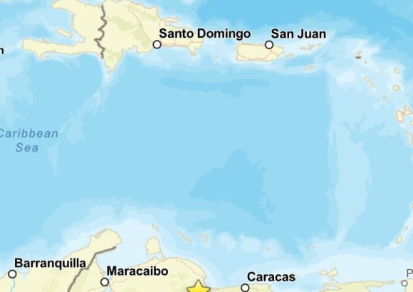
On Wednesday, disaster management authorities in the Dominican Republic activated a formal tsunami warning for the country’s entire southern coastline, following a powerful 7.2 magnitude seismic event detected off the coast of Venezuela. The alert was rolled out after the Dominican Institute of Meteorology (INDOMET) confirmed the earthquake’s registration west of Puerto Cabello, a major port city in northern Venezuela.
Juan Manuel Méndez, director of the Dominican Republic’s Emergency Operations Center (COE), announced a tiered alert system tailored to different stretches of the southern shore. A yellow alert, the higher of the two tiers, is in effect for the coastal corridor running from the southwestern border province of Pedernales east to the southern coastal province of Barahona. For the remaining section of the southern coast, extending from Barahona all the way to the eastern province of La Altagracia—home to the popular tourist hub of Punta Cana—a green alert has been implemented.
In his public address, Méndez emphasized the urgent need for residents living along the coastline and in identified high-risk zones to adhere to all precautionary guidance. He also issued a formal directive to national and local emergency response agencies to immediately activate their established safety protocols, with the core goal of safeguarding civilian lives and protecting personal and public property from potential harm.
Preliminary seismic data published by INDOMET outlines key details of the earthquake. The tremor hit at 6:04 p.m. local Venezuela time, with a relatively shallow focal depth of just 10 kilometers below the ocean surface. Geocoordinates place the epicenter at latitude 10.407 and longitude -68.493, which is roughly 53 kilometers west of Puerto Cabello.
To mitigate potential risk from tsunami activity, INDOMET has issued clear guidance for at-risk coastal populations: residents should evacuate low-lying shoreline areas immediately, and move to elevated locations that sit at least 20 meters above sea level, or relocate a minimum of two kilometers inland if higher ground is not immediately accessible.
Additional guidance has been issued for maritime users: all small and medium-sized watercraft have been instructed to stay anchored in protected port facilities for the duration of the alert. Authorities also warned vessels to avoid navigating near coastal rivers and lagoons, where abnormal strong currents linked to a potential tsunami could create life-threatening hazards.