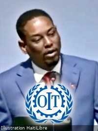
GENEVA — On June 4, 2026, Marc-Elie Nelson, Haiti’s Minister of Social Affairs and Labor, delivered a landmark address to delegates gathered at the 114th International Labour Conference, hosted by the International Labour Organization (ILO) in Geneva. During his speech, Nelson laid out a clear vision for deepened collaboration between Haiti and the global labor body, framing targeted cooperation as a critical catalyst to renew systems that deliver inclusive growth, open constructive social dialogue, and expand access to dignified work across the Caribbean nation.
A central priority of Nelson’s address was a formal call for a strengthened ILO footprint within Haiti, anchored by the establishment of a permanent ILO representative office in the country. He emphasized that the ILO’s decades of specialized global expertise would be transformative for Haiti’s ongoing efforts to update its national labor framework, bringing local legislation into full alignment with internationally recognized labor standards and adapting rules to match the shifting demands of the modern global workforce.
Nelson also used the platform to highlight the Haitian government’s ongoing domestic progress on worker welfare, specifically pointing to recent policy efforts to raise the national minimum wage and expand social safety net coverage for Haitian working people. These steps, he argued, reflect the administration’s commitment to centering worker well-being in national policy priorities.
In addition to bilateral cooperation priorities, Nelson offered public praise for ILO Director-General’s recently released report, *A moment of choice: Harnessing artificial intelligence for decent work*. He noted that the report makes a substantial and timely contribution to global conversations about the future of work, and underscored the meaningful opportunities that AI can bring to expanding labor access and improving working conditions when governed responsibly.
Closing his address, Nelson offered a reflection on what defines a successful nation: “Nations are not measured solely by the size of their economies or the strength of their institutions. They are also measured by how they treat those whose work builds their future.” He concluded by reaffirming that, regardless of political or economic differences between nations, global leaders share a universal core responsibility: to “enable every woman and man to live from their work with dignity, justice, and hope.”