分类: other

  • Rainy Weekend Ahead

    Rainy Weekend Ahead

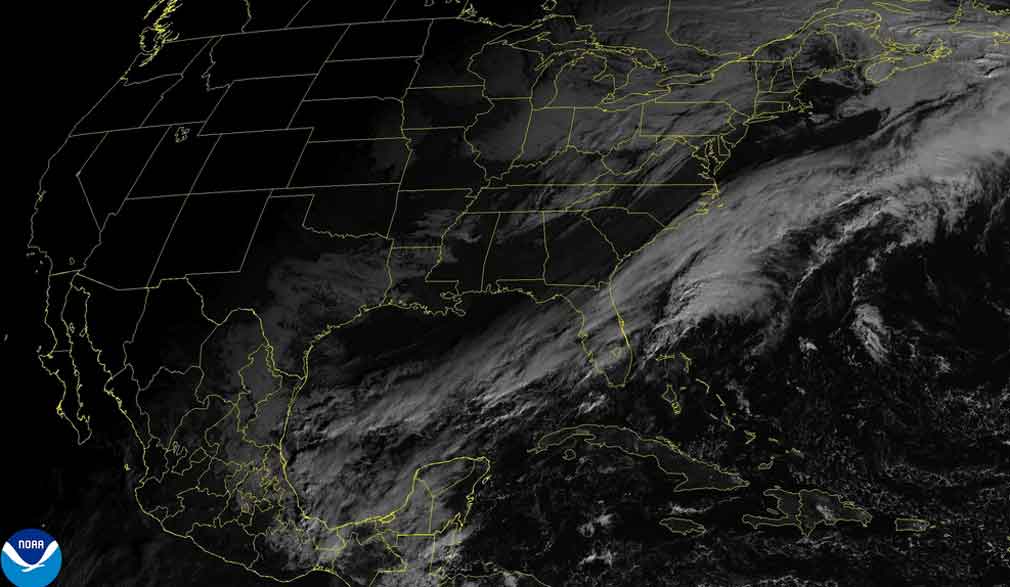
    Meteorological authorities in Belize are forecasting a persistently rainy weekend as a stalled frontal system establishes itself over the nation. The system is expected to generate extensive rainfall and thunderstorms across multiple regions, prolonging wet conditions through Sunday.

    Chief Meteorologist Ronald Gordon confirmed that a saturated northerly airflow has already precipitated substantial rainfall, particularly affecting central Belize. Preliminary data from weather monitoring stations indicates precipitation accumulations ranging from one to three inches in Belize City within the past 24-hour period. The community of Hattieville experienced significantly heavier downpours, registering between five and six inches as intense rainfall persisted through nighttime hours into early morning.

    According to meteorological analysis, the approaching frontal boundary will remain nearly stationary over Belize during the coming days. Gordon elaborated on the atmospheric conditions: “A frontal boundary is currently approaching the area, preceded by a moisture-laden northeasterly airflow that is sustaining this coastal precipitation activity.” The forecaster further indicated that residents should anticipate “continued showers and potentially thunderstorms throughout Saturday extending into portions of Sunday.”

    The precipitation pattern is projected to initiate across northern and central territories before propagating nationwide. The Meteorological Service indicates that gradual atmospheric improvement is anticipated to commence by Monday, suggesting a return to more typical weather conditions.

  • Cold front to arrive in western Cuba this afternoon

    Cold front to arrive in western Cuba this afternoon

    Meteorological authorities in Cuba have issued a detailed forecast indicating a significant shift in weather patterns for the nation’s western region. The Institute of Meteorology (Insmet) reports that residents in the provinces of Pinar del Rio, Mayabeque, and the capital city of Havana should prepare for increasing cloud cover commencing in the late afternoon hours. This cloud development is expected to precipitate into showers and sustained rainfall, with meteorological models projecting an intensification of these conditions as evening approaches.

    The deteriorating weather system will bring multiple consequential effects across western Cuba. A notable increase in wind velocity is anticipated to commence tomorrow, adding another element to the unsettled conditions. Furthermore, a continued downward trend in maximum temperatures is forecasted, with the most significant drop expected by Friday, marking a distinct shift from recent conditions.

    Temperature parameters have been specifically outlined by Insmet meteorologists. Maximum daytime temperatures across affected regions will range between 28°C and 31°C (82°F and 88°F), with inland areas experiencing the warmer readings. Overnight minimums will provide some relief, settling between 21°C and 24°C (70°F and 75°F).

    Wind patterns will undergo a distinct evolution throughout the forecast period. Initial light and variable winds are predicted to shift, becoming consistently northeasterly along Cuba’s northern coastline. Wind speeds are expected to range between 10 to 25 kilometers per hour, with notably stronger gusts projected for the northwestern coastal areas. Marine conditions will reflect this atmospheric activity, with swells developing along both eastern coastlines. The northwestern coast will experience a gradual increase in swell activity beginning in the afternoon, while the remainder of the Cuban coast will see only slight swells, according to the comprehensive Insmet analysis.

  • LIVE: Opening Ceremony of the CCJ Academy for Law 8th Biennial Conference

    LIVE: Opening Ceremony of the CCJ Academy for Law 8th Biennial Conference

    In today’s digital age, social media platforms have become a cornerstone of communication and information dissemination. The act of sharing content—whether through tweets, pins, or posts—has transformed how individuals and organizations connect with their audiences. Visual elements, particularly images, play a pivotal role in capturing attention and enhancing engagement. For instance, a compelling image can evoke emotions, convey messages succinctly, and drive user interaction. The integration of multimedia content into social media strategies has proven to be a powerful tool for amplifying reach and fostering meaningful connections. As the digital landscape continues to evolve, the importance of leveraging visual storytelling and interactive sharing mechanisms remains paramount for effective communication.

  • LIVE from 10AM: Dominica’s 4th Meeting of the 3rd Session of the 11th Parliament

    LIVE from 10AM: Dominica’s 4th Meeting of the 3rd Session of the 11th Parliament

    In the ever-evolving digital landscape, the phenomenon of live content sharing has emerged as a pivotal element of online interaction. Platforms enabling users to share, tweet, pin, and engage with live content are redefining the boundaries of real-time communication. This trend not only enhances user engagement but also fosters a sense of immediacy and community among participants. As live content continues to gain traction, it is reshaping the way information is disseminated and consumed, offering a dynamic and interactive alternative to traditional media formats. The implications of this shift are profound, influencing everything from marketing strategies to the dissemination of news and entertainment.

  • Cool airflow creates pleasant temperatures and isolated showers

    Cool airflow creates pleasant temperatures and isolated showers

    In the early hours of Sunday, the Dominican Republic witnessed a shift in weather patterns as the northeast wind brought cloudy skies and scattered rains to several provinces, including Puerto Plata, Espaillat, Hermanas Mirabal, Hato Mayor, Samaná, and Santiago. The Dominican Institute of Meteorology (Indoemt) predicts that skies will clear up across most regions by midday, with only brief and isolated showers expected, particularly in the Central Mountain Range and the northeast areas.

    Looking ahead to Monday, the weather is expected to remain relatively dry and stable. Most of the country will enjoy clear skies, with very light and isolated showers likely during the early morning or late evening. These sporadic rains will be caused by moisture carried by east/northeast winds, affecting the northern coast, the Cibao region, and the Central Mountain Range.

    Temperatures are set to drop, bringing a more pleasant and cooler feel, especially during nighttime and early morning hours. This cooling trend will be most noticeable in mountainous areas and inland valleys, where fog may also form in higher elevations. The influx of fresh air driven by east/northeast winds is responsible for these cooler conditions, which are expected to persist in the coming days.

    In Greater Santo Domingo, residents can expect scattered clouds, with temperatures ranging from a minimum of 20°C to 22°C and a maximum of 30°C to 32°C.

  • Wisselvallig weer met bewolking en regen

    Wisselvallig weer met bewolking en regen

    The day begins predominantly dry across much of the country, with localized fog patches along rivers and low-lying areas in the early morning. As the morning progresses, the skies clear, leading to a mix of sunshine and thin cloud cover. By the afternoon, cloudiness gradually increases, particularly in inland areas and the Brokopondo and Sipaliwini districts, where isolated rain and thunderstorms may develop. These showers can be brief but intense in some locations. Coastal regions, however, remain calmer, though a light shower cannot be entirely ruled out. Temperatures in the afternoon range between 30 to 33 degrees Celsius, accompanied by high humidity that may make it feel warmer. Winds are moderate, predominantly from the east to northeast. In the evening and overnight, shower activity and cloud cover decrease once again, resulting in dry conditions along the coast, while the southern regions may continue to experience occasional showers for a longer duration.

  • Wisselend zonnig en bewolkt

    Wisselend zonnig en bewolkt

    Tomorrow’s weather forecast predicts a mix of sunshine and clouds throughout the day. In the afternoon and early evening, light to moderate showers are expected to occur locally, particularly in coastal areas and parts of the inland regions. There is also a possibility of thunderstorms and wind gusts in the coastal zones. Winds will vary from northeast to southeast, with speeds reaching up to 20 km/h. Locally, conditions may become windier, with temporary increases in wind speeds up to 50 km/h. Temperature-wise, the day will see highs of 33°C and lows of 23°C.

  • Kapel Nationaal Leger viert 83-jarig bestaan

    Kapel Nationaal Leger viert 83-jarig bestaan

    On November 19, a news article was published with minimal textual content and an accompanying image. The article, dated 19 November at 02:44, lacks detailed information, leaving readers with more questions than answers. The image, hosted at ‘https://news-minio.triplec.cc/news/2025/11/19/e8d27ce2ba7573ef9a6a656615a64572.webp’, remains the sole focal point of the piece. Without additional context or narrative, the purpose and significance of the article remain unclear. This minimalist approach to news reporting has sparked curiosity and speculation among readers, who are left to interpret the content on their own.

  • Bewolkt met wat regen

    Bewolkt met wat regen

    The day begins with overcast skies and a very light easterly wind. Cloud cover is expected to persist throughout the day, with temperatures potentially rising to a peak of 34°C in the afternoon. There is a possibility of light rain occurring during this period. As the evening approaches and into the night, light rain is also forecasted. The wind direction will shift to the northeast but will remain weak. Temperatures are expected to cool down to around 23°C by nighttime.

  • LIVE: The Diocese of Roseau Jubilee Youth Festival

    LIVE: The Diocese of Roseau Jubilee Youth Festival

    In the digital age, social media platforms have revolutionized the way people interact and share information. The simple acts of sharing, tweeting, and pinning content have become integral to modern communication. These actions not only facilitate the dissemination of information but also foster a sense of community and connection among users. Social media engagement has evolved into a powerful tool for individuals and organizations alike, enabling them to reach a global audience with just a few clicks. The ease of sharing content has also led to the rapid spread of ideas, trends, and news, making social media a cornerstone of contemporary digital culture. As platforms continue to innovate, the ways in which people engage with content are expected to become even more diverse and dynamic.