分类: environment

  • OKGS treedt op tegen illegale goudwinning in Brownsberg Natuurpark

    OKGS treedt op tegen illegale goudwinning in Brownsberg Natuurpark

    Suriname’s regulatory body for the small-scale gold sector has taken decisive action against unauthorized mining operations inside a protected national nature reserve, seizing mining equipment and ordering illegal prospectors to leave the ecologically sensitive area.

    The Commission for the Ordering of the Small-Scale Gold Sector (OKGS) launched an inspection of Brownsberg Nature Park on Tuesday this week, following confirmed reports of unpermitted gold extraction activity at multiple sites across the protected territory. Managed by the Suriname Nature Conservation Foundation (STINASU), Brownsberg Nature Park is one of the country’s key protected ecological areas, home to unique biodiversity and fragile ecosystems that are highly vulnerable to the destructive impact of unregulated mining.

    During the inspection, OKGS teams discovered stockpiles of gold mining equipment near the Irenevallen waterfall, which were immediately seized as evidence. All illegal miners found on site were formally ordered to evacuate the protected zone immediately. The inspection also included working discussions with STINASU to clarify the formal boundary line of the protected area, a step designed to eliminate ambiguity around zones where all gold extraction activities are permanently prohibited.

    OKGS was established specifically to improve governance of Suriname’s growing small-scale gold mining sector, with a multi-pronged mandate that includes addressing widespread environmental degradation, cracking down on unlicensed activity and associated criminal networks, regulating financial flows within the sector, and ensuring the Surinamese state captures a fair share of revenue from gold production and export. The commission operates in close coordination with a range of national and local stakeholders, including the Ministries of Justice and Security, Defense, and Natural Resources, STINASU, traditional community leaders, and district commissioners, with participating partners adjusted based on the specific region of operations.

    As part of its broader sector reform push, OKGS launched a six-month pilot registration program for all individuals working in or connected to the small-scale gold sector in early July. The soft launch of the registration scheme is rolling out across multiple mining regions over the half-year pilot period. Miners seeking formal registration can also submit applications directly at the OKGS headquarters located at 181 Mr. Jagernath Lachmonstraat. Officials confirmed that follow-up inspections of the Brownsberg area will be conducted in the near future to ensure no illegal mining activity resumes, as part of ongoing efforts to bring structured regulation to the small-scale gold sector and protect Suriname’s critical natural protected areas.
  • BMS monitors tropical wave east of Barbados

    BMS monitors tropical wave east of Barbados

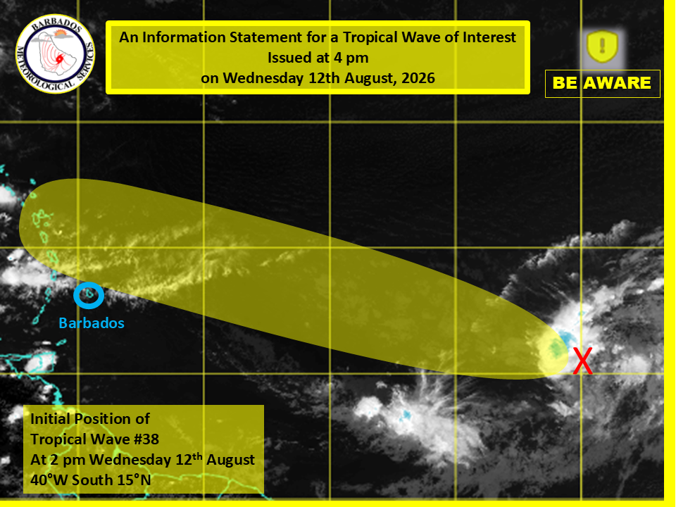
    Residents of Barbados have been put on alert to watch a budding tropical disturbance moving across the Atlantic Ocean, which is forecast to bring elevated temperatures and scattered storm activity to the island by the end of the week. In an official advisory released Wednesday afternoon, the Barbados Meteorological Services (BMS) confirmed that no tropical storm watches or warnings have been activated for the territory yet. Still, local forecasters note that the approaching system will interact with slowing wind speeds across the region Friday and Saturday, creating conditions for hotter-than-average temperatures and pockets of heavy afternoon showers and thunderstorms across parts of the island.

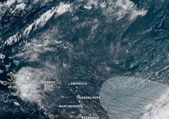
    As of 2 p.m. Wednesday, the tropical wave was mapped approximately 1,338 miles, or 2,156 kilometers, east of Barbados. The disturbance is linked to a broad low-pressure system that is currently generating scattered, disorganized thunderstorm activity across the central Atlantic. According to the BMS analysis, broader environmental conditions are only marginally supportive of gradual strengthening of the system over the coming days, as it tracks generally west to west-northwest across the ocean.

    Forecasters add that the vast majority of the system’s active weather is projected to stay north of Barbados, reducing the risk of severe direct impacts for the island. The BMS has announced plans to release its next official update on the system’s progress at 11 a.m. local time Thursday, to keep the public informed of any changing conditions.

  • WEATHER (12:00 PM, 12 August): Tropical wave affecting region, two more being monitored in Eastern Atlantic

    WEATHER (12:00 PM, 12 August): Tropical wave affecting region, two more being monitored in Eastern Atlantic

    Meteorological agencies have issued a multi-hazard weather warning for the Caribbean region, as a combination of a passing tropical wave, a surge of Saharan dust, and building seas are set to bring disruptive and potentially dangerous conditions through the weekend. The ongoing tropical wave, which is expected to maintain its influence over the area through tonight, will bring widespread overcast skies, scattered rain showers, and a chance of isolated intense thunderstorm activity. Local authorities are urging residents in low-lying flood-prone zones and steep terrain areas at risk of landslides and rockfalls to stay vigilant and prepare for potential emergency events. Wind speeds are also projected to climb through tonight and remain elevated through the weekend, with higher elevation mountainous regions facing the greatest risk of stronger gusts.

    Beginning this evening, atmospheric concentrations of Saharan dust will begin to rise, with the hazy conditions expected to persist through Saturday morning. This dust surge will degrade air quality to moderate or poor levels and cut down horizontal visibility across the affected area. Health officials are reminding vulnerable groups — including people living with asthma, seasonal allergy sufferers, and anyone with pre-existing sensitivity to fine particulate dust — to continue taking all recommended protective measures, such as limiting prolonged outdoor exposure. For maritime operations, reduced visibility from dust requires all vessels to carry fully functional navigational equipment to avoid accidents at sea.

    Sea conditions are also worsening across the region over the coming 24 hours. Forecasters predict slight to moderate swells initially, with west coast waves topping out at 3 feet and east coast waves reaching up to 7 feet. By tonight, those swells are set to build to 5 feet along the west coast and 8 feet along the east coast. Operators of small vessels and recreational sea bathers have been warned to avoid unnecessary travel and water activities due to the unsafe conditions.

    Beyond the immediate weather event, the U.S. National Hurricane Center is actively tracking two additional tropical waves moving across the eastern Atlantic. The first of these waves has a high probability of organizing into a stronger tropical system over the next seven days as it tracks west to west-northwest, and it is projected to reach the broader Caribbean region by the weekend. Authorities across the Lesser Antilles have advised local populations and interest groups to closely track updates on the wave’s trajectory. For mariners operating near Dominica, officials stress the importance of checking regular weather updates throughout the week, as sea conditions are expected to begin deteriorating by Thursday and could decline further through the weekend.

    In a separate update on Atlantic tropical activity, Tropical Storm Christobal has formed in the north-central Atlantic, but forecasters confirm it currently poses no threat to the Caribbean region covered by the current warning.

  • Iberostar advances coral reef conservation with research lab in Bávaro

    Iberostar advances coral reef conservation with research lab in Bávaro

    As climate change continues to drive rising ocean temperatures and widespread coral bleaching across the Caribbean, tourism giant Iberostar Hotels & Resorts is stepping up its commitment to marine ecosystem protection through an expanded portfolio of coral reef conservation and restoration initiatives in the Dominican Republic.

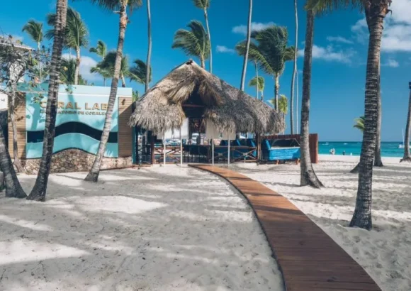
    At the company’s Playa Bávaro location, a dedicated on-site coral laboratory houses a specialized genetic bank preserving samples from nine distinct species of reef-building corals. The facility’s in-house team of scientific researchers carries out cutting-edge thermotolerance experiments, designed to map how different coral species react to elevated ocean heat levels. The data gathered from these studies will directly inform and strengthen future reef restoration projects across the region.

    All of these conservation efforts fall under the umbrella of Iberostar’s flagship sustainability program, “Wave of Change”, an initiative built to advance the principles of responsible tourism and safeguard vulnerable coastal ecosystems around the globe. To date, the company’s global nature conservation strategy has brought together more than 30 independent scientists and marine specialists, contributed to 13 peer-reviewed scientific publications, and developed two standardized restoration protocols that are now widely used by coral conservation professionals worldwide.

    In collaboration with the Dominican Republic’s Ministry of Environment and Natural Resources, with initial seed funding from the German Development Cooperation (GIZ), Iberostar has already completed the rehabilitation of roughly one hectare of degraded reef habitat within the Playa Bávaro tourism complex. This restored coastal zone now acts as a critical refuge for native endemic marine species, and functions as a natural seed source to support natural vegetation regeneration across nearby damaged ecosystems.

    Iberostar’s conservation footprint extends well beyond this single site in the Dominican Republic. Across the entire Caribbean region, the company operates seven underwater coral nurseries, where heat-tolerant coral fragments are grown before being outplanted to damaged reef sites. It also runs three land-based coral research laboratories, located in the Dominican Republic, Mexico, and Jamaica respectively.

    Most recently, the company laid the groundwork for long-term institutional collaboration on marine conservation: In February 2026, the Iberostar Foundation partnered with the Autonomous University of Santo Domingo to launch the Iberostar Sea Initiative, a program focused on advancing marine research, providing specialized conservation training, and facilitating cross-sector knowledge transfer. Just two months later, in April, Iberostar signed a formal partnership agreement with the Dominican Ministry of Environment to support coordinated conservation and restoration work for coastal and marine ecosystems in the popular tourist regions of La Altagracia and Puerto Plata.

  • Tropical Storm Cristobal weakens into depression

    Tropical Storm Cristobal weakens into depression

    In an update released Thursday, the Dominican Institute of Meteorology (Indomet) announced that Tropical Storm Cristobal has completed its transition into a remnant low-pressure system, with complete dissipation forecast to occur before the end of the day.

    As of the latest observation, the weakening system sits roughly 980 kilometers west of the Azores archipelago. It carries maximum sustained wind speeds of 55 kilometers per hour and is tracking eastward at a forward speed of around 26 kilometers per hour. Thanks to its current position and projected path, Indomet confirmed that Cristobal poses no immediate threat to Dominican territory, ruling out any risk of landfall or severe impact on the island nation.

    While Cristobal fades, the agency’s meteorology teams are actively monitoring two separate tropical disturbances linked to tropical waves moving across the Atlantic basin. The first of these systems is positioned between the western coastline of Africa and the Lesser Antilles. Forecasters have assigned it an 80% probability of strengthening into a named tropical cyclone over the coming seven-day period. The second disturbance, located several hundred kilometers south-southwest of the Cape Verde Islands, has a lower but still notable 30% chance of development within the next 48 hours, with that probability rising to 50% when extended to the full seven-day forecast window.

    Beyond the Atlantic systems, ongoing weather activity is already affecting portions of the Dominican Republic. Indomet linked the steady rainfall impacting the country’s Caribbean coast and northeastern regions to a combination of a tropical wave and an upper-level trough moving through the area. The forecast calls for continued heavy downpours, scattered thunderstorms, and occasional wind gusts across multiple provinces, including Hato Mayor, Monte Plata, Sánchez Ramírez, La Vega, Duarte, Santiago Rodríguez, Dajabón, and Monte Cristi. Mountainous and border zones across these areas are expected to see the most intense weather activity.

    In response to the persistent rainfall, the National Forecast Center has issued and maintained a formal weather alert for the capital region of Santo Domingo, the National District, San Cristóbal, and Peravia. The alert was issued due to elevated risks of urban flooding as saturated stormwater systems struggle to handle continued precipitation.

  • Tropical Storm Cristobal No Threat to Caribbean

    Tropical Storm Cristobal No Threat to Caribbean

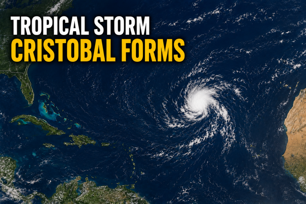
    The 2026 Atlantic hurricane season has marked its third named storm earlier than many forecasters expected, as Tropical Storm Cristobal has officially formed in the central subtropical Atlantic. The developing system, previously identified by meteorologists as Invest AL93, took shape in waters well to the west-southwest of the Azores archipelago, beating another larger disturbance monitored across the southern tropical Atlantic to earn a formal name.

    According to the latest update from the U.S. National Hurricane Center, published at 3 p.m. GMT on Wednesday, the newly christened storm is positioned near 36.7 degrees north latitude and 43.0 degrees west longitude. It carries maximum sustained winds of 45 miles per hour, the minimum threshold for a tropical storm, and is currently tracking quickly eastward across open ocean at 25 miles per hour.

    Thanks to its current position and projected forward path, Cristobal will remain hundreds of miles from any Caribbean landmasses for the entirety of its forecast lifecycle. No coastal watches, warnings, or emergency preparations have been issued for any regional communities in relation to this system.

    With Cristobal posing no immediate danger to populated coastal areas, regional meteorological agencies and disaster response teams are continuing to focus their monitoring efforts on the second disturbance, designated AL92, which is currently moving westward across the central tropical Atlantic.

  • BREAKING: Tropical Storm Cristobal Forms Over Central Atlantic

    BREAKING: Tropical Storm Cristobal Forms Over Central Atlantic

    The 2026 Atlantic hurricane season has marked its third named system, as Tropical Storm Cristobal officially formed over the central subtropical Atlantic on Wednesday. According to the latest official update from the U.S. National Hurricane Center (NHC), released in its 3 p.m. GMT advisory, the newly formed storm carries maximum sustained winds of 45 miles per hour, with gusts that reach even higher speeds.

    As of the advisory’s publication, the storm’s center was positioned approximately 880 miles west of the Azores archipelago, at coordinates 36.7 degrees North latitude and 43.0 degrees West longitude. Cristobal is currently tracking eastward at a fast clip of 25 miles per hour, though forecasters project a shift in trajectory and speed over the coming hours. The NHC predicts the storm will curve toward the east-northeast and decelerate through Wednesday and into Wednesday night.

    One of the most critical takeaways from the NHC’s update is that Cristobal poses no immediate danger to any coastal or inland landmasses. No coastal watches or warnings are currently in effect, and the agency has not identified any hazards that will impact populated or terrestrial areas. Tropical-storm-force winds extend only 90 miles outward from the storm’s center, all of which remain over open ocean waters.

    Meteorologists also expect Cristobal to be a short-lived weather system. The NHC’s forecast trajectory calls for gradual weakening starting in the near term, with the entire system expected to fully dissipate sometime on Thursday. As of Wednesday’s midday advisory, the storm’s minimum central pressure was measured at 1008 millibars. The next full public update on Cristobal’s status and track is scheduled to be released at 9 p.m. GMT Wednesday.

  • Tropical Depression has 80% chance of becoming a tropical cyclone within both 48 hours and seven days

    Tropical Depression has 80% chance of becoming a tropical cyclone within both 48 hours and seven days

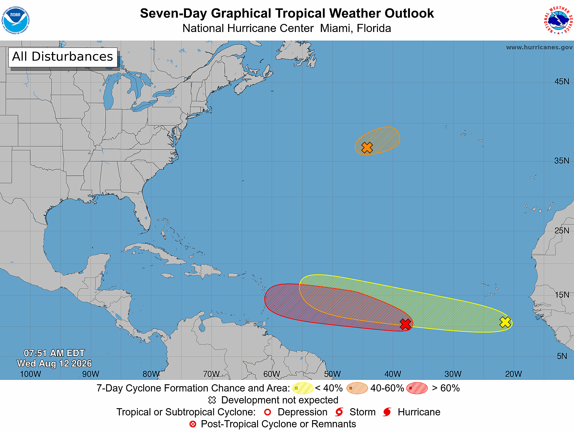
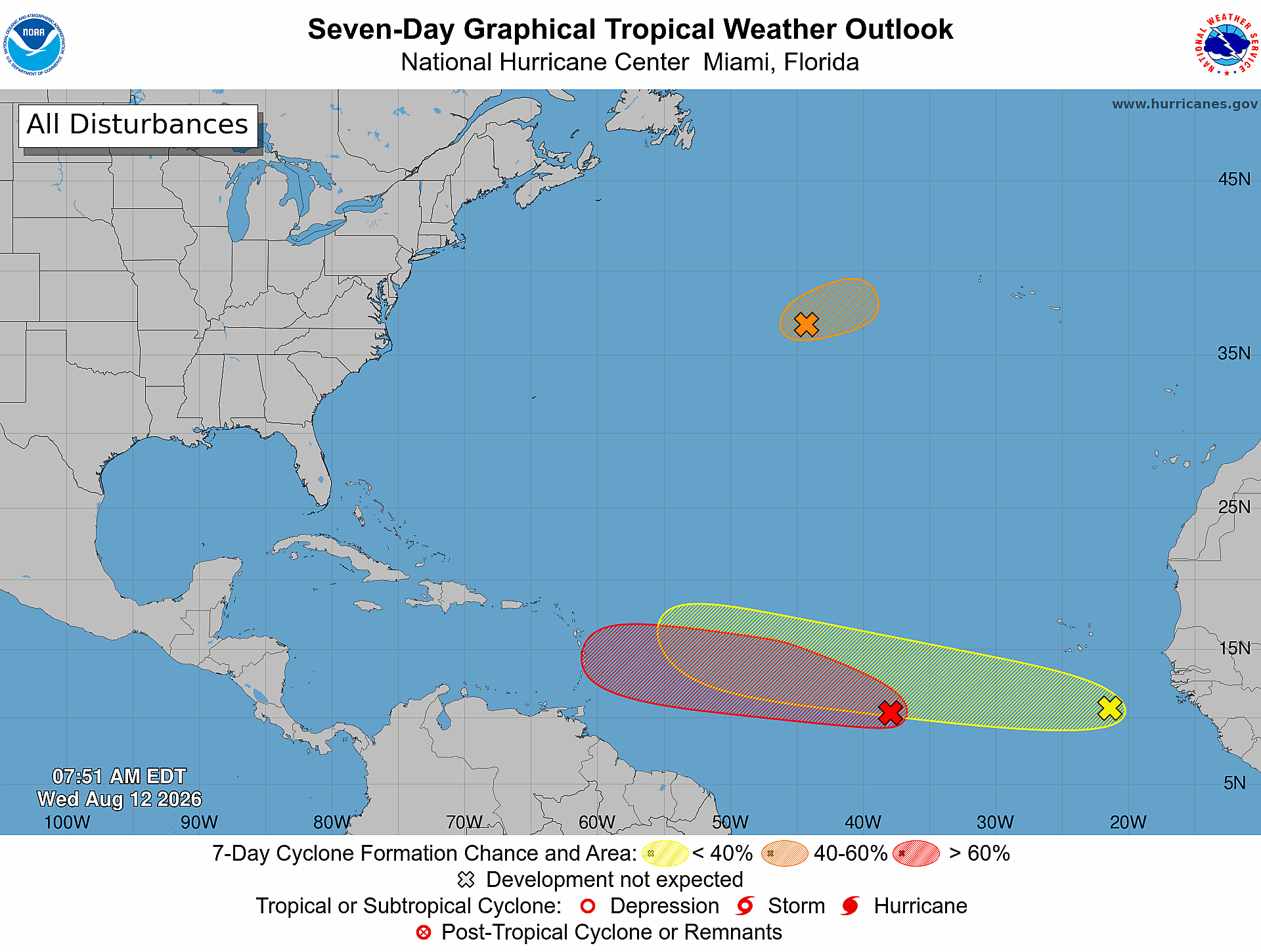
    Meteorologists at the U.S. National Hurricane Center are tracking three separate tropical systems across the Atlantic Ocean, with one disturbance showing sharply increased odds of strengthening into a named tropical cyclone in the coming week.

    In its latest public advisory issued at 8 a.m. Eastern Time Wednesday, the agency confirmed that Tropical Disturbance AL92 is currently generating disorganized showers and thunderstorm activity roughly 900 miles west-southwest of the Cabo Verde Islands, off the western coast of Africa. Favorable atmospheric and oceanic conditions are forecast to persist over the central tropical Atlantic over the next several days, which will create room for AL92 to steadily organize as it tracks along a west to west-northwest path.

    As of Wednesday’s update, forecasters have raised the probability that AL92 will develop into a tropical depression to 80% for both the 48-hour and seven-day forecasting windows. This marks a notable increase from earlier projections that put the system’s development odds lower.

    AL92 is not the only system being watched by hurricane specialists this week. A second disturbance, labeled AL93, is positioned around 1,050 miles east-northeast of Bermuda in the North Atlantic. This system currently holds a 50% chance of briefly strengthening into a tropical storm before it moves into much cooler ocean waters on Thursday, a shift that will halt any further development.

    The third system, a broad tropical wave that has just moved off the western coast of Africa, carries lower development odds at this stage. Forecasters assign it a 20% chance of organization within the next 48 hours and a 30% chance through the next seven days. Like AL92, it is expected to progress west or west-northwest across the tropical Atlantic basin over the coming days.

    The National Hurricane Center continues to issue regular updates on all three systems as the Atlantic hurricane season remains active, urging residents and maritime interests across the basin to monitor changes in forecasts over the coming days.

  • Sargassum Accumulates Along Jabberwock Beach

    Sargassum Accumulates Along Jabberwock Beach

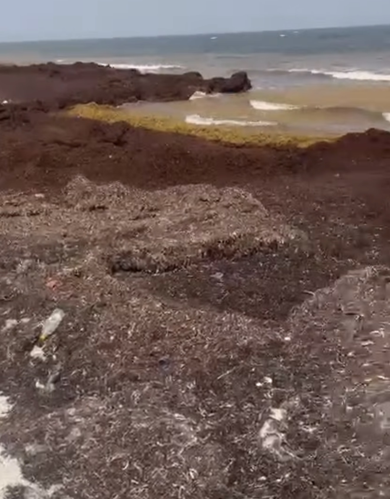
    A thick accumulation of brown sargassum seaweed has blanketed stretches of Jabberwock Beach, coating the shoreline and creating unwelcome conditions for visitors and local communities. This latest proliferation of the marine algae is part of a broader regional challenge, as Caribbean nations once again grapple with a major sargassum season that has become an annual environmental and economic concern.

    Projections from the University of South Florida’s Optical Oceanography Laboratory paint a worrying picture for the coming years: by 2026, the total volume of sargassum blooming across the Atlantic is expected to hit at least the second-highest level recorded since systematic monitoring began. This growing trend of increasingly large sargassum outbreaks has put mounting pressure on coastal communities throughout the Caribbean basin.

    Unlike many harmful invasive species, sargassum is a naturally occurring brown algae that forms large floating mats across the open Atlantic Ocean. Offshore, these mats actually play a valuable ecological role, serving as critical habitat and feeding grounds for a wide range of marine life, from small juvenile fish to sea turtles. The situation changes dramatically, however, when large quantities of the algae wash onto sandy shorelines and begin to decompose. As it breaks down, sargassum releases a pungent, unpleasant odor that drives away tourists and disrupts daily life for coastal residents.

    To combat the persistent problem, regional governments, beachfront hotels, and local tourism businesses have poured millions of dollars into annual cleanup operations and the installation of offshore containment barriers designed to stop sargassum from reaching shore. Beyond mitigation efforts, researchers and innovative entrepreneurs across the region and beyond are actively investigating potential commercial uses for the harvested algae, exploring applications that could turn the nuisance into a valuable resource. Promising areas of development include using sargassum as a base for organic agricultural fertilizers, a feedstock for renewable biofuels, and even a raw material for sustainable textiles and other consumer goods.

  • Hurricane season, the MARNDR is working in Ravine Sèche (Torbeck)

    Hurricane season, the MARNDR is working in Ravine Sèche (Torbeck)

    As hurricane season brings heightened risk of extreme weather and flooding across Haiti, the country’s Ministry of Agriculture, Natural Resources and Rural Development (MARNDR) has ramped up targeted risk-reduction interventions in vulnerable rural communities in Haiti’s southern region.

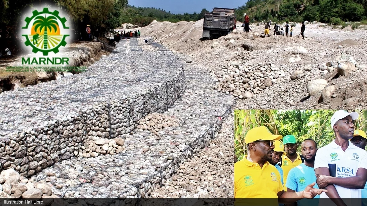
    In the 4th communal section of Péan, located within the commune of Torbeck, MARNDR is leading riverbank stabilization work along roughly 750 linear meters of Ravine Sèche through the Resilient Agriculture for Food Security Project (PARSA), an initiative backed by World Bank funding. The core goal of the infrastructure upgrade is to shield local residents and protect critical agricultural land from destructive erosion and flooding triggered by heavy seasonal downpours.

    Construction progress is already well advanced: project teams have installed more than 600 linear meters of reinforced gabion retaining walls, a structural solution designed to shore up eroding riverbanks, cut down on sediment loss, and lower the risk of catastrophic damage to adjacent farmland and local infrastructure.

    During an official inspection visit to the construction site, Agriculture Minister Marcelin Aubourg stressed that the project directly responds to longstanding safety concerns raised by local residents of Péan. He went on to highlight the significant agricultural potential of the Torbeck region, calling out the nearby Leblanc farm as a particularly valuable high-productivity agricultural site. Aubourg expressed public satisfaction with the pace and quality of work completed to date, commended the contracting firm for its on-the-ground efforts, and reaffirmed that the finished infrastructure will substantially reduce the harm extreme weather events inflict on the local community.

    Acknowledging the persistent threat that unregulated erosion of Ravine Sèche poses to the area, Aubourg also issued a public call for residents to remain vigilant and help protect the new infrastructure. He specifically warned against the removal or relocation of gabion stones by bad actors, a practice that would compromise the structural integrity of the riverbanks and put the entire community at risk.

    For local families that have lived alongside the unprotected ravine for years, the ongoing construction has been met with widespread relief and cautious optimism. For generations, these communities have faced repeated disruption to their farming operations and livelihoods from annual flooding and erosion, and the riverbank protection project marks the first concrete intervention to address this chronic threat.

    Beyond the long-term safety and food security benefits the finished works will deliver, the project has already generated immediate economic gains for local households. Dozens of area residents have been hired to support construction activities, giving them access to on-the-job income while the project progresses, creating a dual benefit for the rural community.