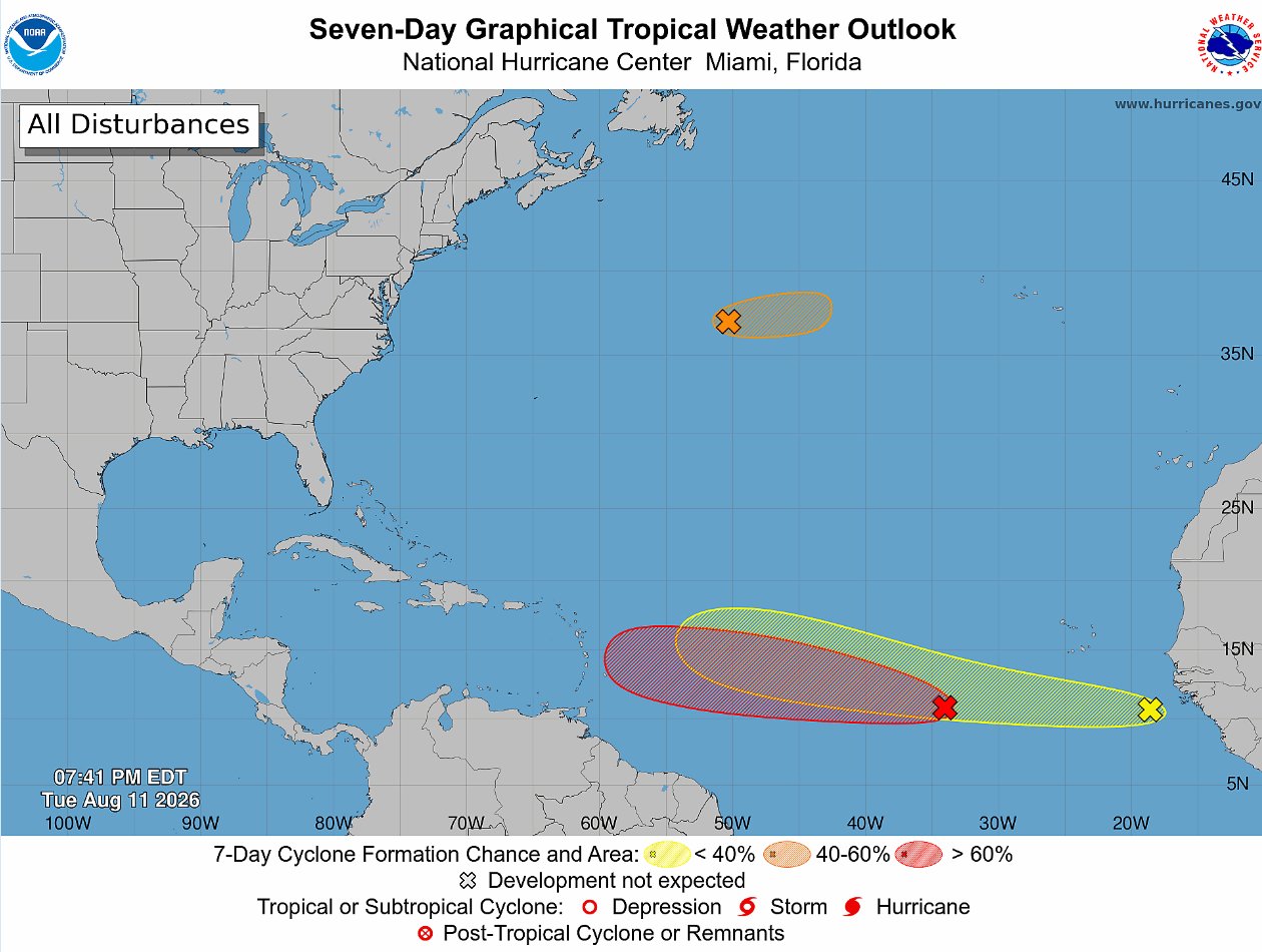
As the 2024 Atlantic hurricane season progresses, meteorologists are tracking three separate disturbed weather systems across the basin, with one emerging as the most likely candidate to strengthen into a named tropical cyclone in the coming week. The U.S. National Hurricane Center (NHC) updated its outlook Tuesday evening, reporting that a tropical wave moving through the central Atlantic has seen its odds of organized development jump sharply, with forecasters now putting its seven-day formation chance at 80 percent.
Designated by the NHC as System AL92, this disturbance was located roughly 700 miles southwest of the Cabo Verde Islands as of 8 p.m. ET Tuesday. While the system is still in its early stages of organization, the NHC noted that scattered showers and thunderstorms linked to AL92 have already begun to consolidate, a key early sign that tropical cyclone formation is underway. Forecasters project the system will continue on a westward to west-northwestward track across the central tropical Atlantic over the next several days, moving through an environment where ocean temperatures and wind patterns are growing increasingly favorable for strengthening.
In its updated probability assessment, the NHC said AL92 now has a 60 percent chance of developing into a tropical depression within the next 48 hours, up from earlier lower estimates. If the system continues to organize as expected, it will become the season’s next named tropical storm once its sustained wind speeds reach 39 miles per hour.
A second system, designated AL93, is tracking across the higher-latitude central Atlantic, far north of AL92. Forecasters say this system has a limited window for development, with a short-lived tropical depression or weak tropical storm possibly forming before the end of Wednesday. Beyond that, unfavorable conditions are expected to halt the system’s organization.
The third system under watch is a newly emerged tropical wave that just moved off the west coast of Africa into the eastern Atlantic. Right now, this system’s shower and thunderstorm activity remains disorganized, and it has low odds of development in the near term. The NHC estimates just a 10 percent chance of formation within 48 hours, rising to only 20 percent over the full seven-day outlook window as it drifts westward across the eastern and central Atlantic.
As of Tuesday night, the NHC confirmed there were no active tropical cyclones anywhere across the entire Atlantic basin. Forecasters will continue to issue daily updates on all three disturbed systems, with more frequent advisories going into effect once any system shows clear signs of sustained organization.