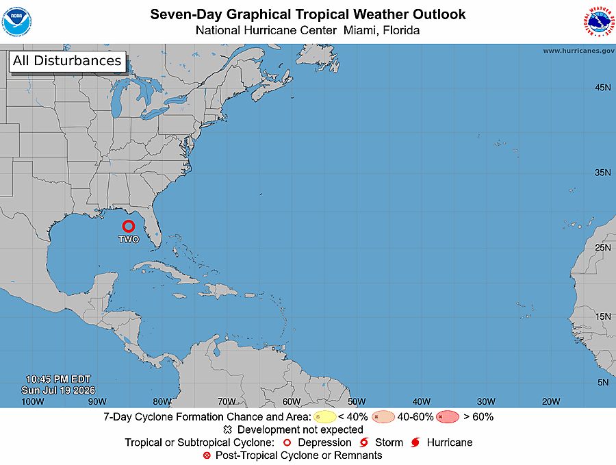
Overnight on July 19, a low-pressure system known as Invest 91L that had been lingering in the Gulf of Mexico off Florida’s coastline strengthened into the first tropical depression of the 2026 Atlantic hurricane season’s early cycle, officially designated Tropical Depression Two, according to updated forecasts from the U.S. National Hurricane Center (NHC).
As of 8 p.m. Eastern Time on Sunday, the storm’s center was positioned roughly 180 miles south-southeast of Panama City, Florida, at coordinates 27.5 degrees North latitude and 85.0 degrees West longitude. Right now, the system is stationary, but forecasters project it will begin a slow drift toward the northwest or north-northwest over the next 48 hours, before shifting westward and tracking near or along the northern Gulf Coast over the coming several days.
Currently, the cyclone carries maximum sustained winds of 30 mph with higher gusts, and a minimal central barometric pressure of 1008 mb. Meteorologists say unfavorable atmospheric conditions, including dry Saharan dust and strong upper-level wind shear, will prevent the system from strengthening into a hurricane, but gradual intensification is still expected. The NHC’s latest official advisory projects Tropical Depression Two will strengthen to reach tropical storm status on Monday. If it reaches that threshold, it will be named Bertha, the second named storm of the 2026 Atlantic hurricane season.
In response to the developing system, officials have issued a Tropical Storm Watch for the Florida coastline from the Ochlockonee River eastward to the Alabama border. The NHC warned that tropical storm-force conditions could reach parts of the Florida Panhandle by late Monday, and urged residents and emergency managers across Alabama, Mississippi, Louisiana, and Texas to closely monitor updates, as additional watches could be issued for parts of those states in the next 24 to 48 hours.
While wind impacts are expected to be minor, meteorologists emphasize that heavy rainfall and resulting flash flooding will be the primary hazard posed by the system. Forecasts call for total rainfall accumulation of 2 to 4 inches across the Gulf Coast and adjacent inland areas from western Florida to the Middle Texas Coast through Friday, with isolated locations seeing as much as 8 inches of rain.
AccuWeather meteorologist Alex Duffus noted that the flooding threat remains high even if the system does not fully organize into a tropical storm. “Flash flooding from slow-moving or repeated downpours looks to be the biggest threat from this tropical rainstorm, regardless of its official strength,” Duffus explained.
Notably, the incoming rain brings a mixed picture for the Florida Panhandle, which has been struggling with an extended drought. Meteorologist DaSilva explained that while the precipitation will be beneficial for drought-stricken areas, the prolonged dry conditions actually increase flood risk. “Dry, hard-packed soil cannot absorb water quickly when it hits, so more water will run off the surface instead of soaking in, raising the chance of flash flooding even with moderate rainfall totals,” DaSilva said.
Local emergency management agencies across the region are urging residents to prepare emergency supply kits, clear storm drains of debris, and monitor official forecast updates closely over the coming days as the system evolves.