分类: other

  • A trough is bringing showers; temperatures will drop further.

    A trough is bringing showers; temperatures will drop further.

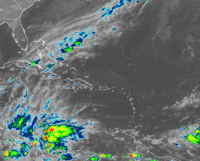
    Meteorological authorities have issued a comprehensive weather advisory for multiple regions, forecasting a dynamic pattern of isolated showers and potential thunderstorms. The conditions are driven by a frontal trough positioned to the northeast of the island.

    Significant precipitation is anticipated across a wide swath of the country, particularly impacting the northern and northeastern provinces, the eastern plains, and the Central Mountain Range. The Office of National Meteorology has identified several specific areas at higher risk, including La Altagracia, La Romana, San Pedro de Macorís, Santo Domingo, San Cristóbal, Peravia, Azua, Barahona, Pedernales, La Vega, Santiago, Monseñor Nouel, Hato Mayor, and Samaná.

    Residents should prepare for a stark thermal contrast throughout the day. Daytime hours will feature notably hot conditions, with peak temperatures felt during the afternoon. Conversely, nights and early mornings will bring cooler, misty conditions to mountainous regions and valleys. Dense fog banks are forecasted, especially in the provinces of Santiago, Espaillat, and Hermanas Mirabal, persisting until morning.

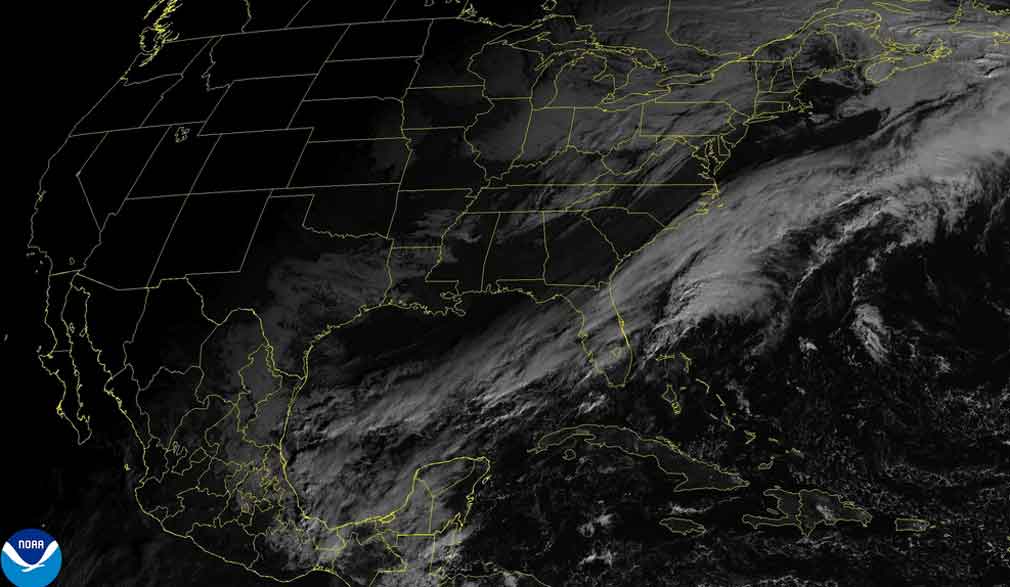
    Looking ahead, meteorological models indicate a shift in conditions for the following day. An easterly wind flow, interacting with the island’s topography, is expected to create a blustery environment. Cloud cover will develop from the early morning, leading to scattered showers primarily on the northern, northeastern, and eastern slopes of the Central Cordillera.

    A critical marine warning accompanies the terrestrial forecast. Officials predict a deterioration in coastal conditions, with an increase in swell size and wind intensity along both the northern and southern coastlines. The public, particularly maritime operators and beachgoers, is urged to exercise extreme caution.

  • Wisselvallig weer met buien

    Wisselvallig weer met buien

    Suriname is experiencing variable weather conditions with locally intense rainfall and thunderstorms developing primarily during morning and early afternoon hours. The day commenced with widespread cloud cover across most regions, accompanied by scattered showers along the coastal stretch from Nickerie to Albina. Morning temperatures ranged between 24-26°C (75-79°F).

    In central and inland regions, substantial cloud formations began developing from late morning onward. These meteorological conditions are expected to evolve into organized lines of showers progressing eastward and southward. Particular areas including Para, Brokopondo and Sipaliwini districts face potential short but intense thunderstorm activity. These systems may produce gusty winds around early afternoon.

    Coastal areas will experience partial cloud reduction during afternoon hours, though isolated showers remain possible. Daytime highs will reach 31-33°C (88-91°F) combined with elevated humidity levels creating uncomfortable conditions.

    The evening forecast indicates predominantly dry conditions along coastal regions with temperatures around 27°C (81°F). Interior regions will maintain cloud coverage for extended periods with late showers remaining possible throughout the evening hours.

  • Climate Passing showers and pleasant temperatures in several provinces

    Climate Passing showers and pleasant temperatures in several provinces

    Meteorological conditions across the Dominican Republic indicate a week commencing with varied weather patterns, according to the latest forecast from the Dominican Institute of Meteorology (Indomet). A weak atmospheric trough is currently influencing weather systems, generating intermittent light to moderate rainfall across multiple provinces including Samaná, María Trinidad Sánchez, Sánchez Ramírez, Monseñor Nouel, Santo Domingo, La Altagracia, El Seibo, and Barahona. Precipitation events are anticipated to intensify during afternoon hours throughout these regions.

    Meanwhile, the remainder of the country can expect predominantly sunny conditions with isolated cloud formations. Temperature readings remain seasonally appropriate, with minimums ranging between 21°C and 23°C and maximums between 30°C and 32°C, creating particularly pleasant conditions during nighttime and early morning hours. These conditions will be most pronounced in mountainous zones and valleys of the Cibao region, especially throughout Santiago, La Vega, and Monseñor Nouel, where periods of fog or mist are forecast for tomorrow.

    The Greater Santo Domingo area, encompassing the National District along with North, East, and West sectors, will experience similar meteorological patterns—sunny skies with intermittent cloud cover and occasional passing showers.

    Weather systems are expected to shift noticeably by Monday with the arrival of a drier air mass combining with an anticyclonic system. This combination will produce predominantly clear skies with minimal rainfall across nearly all territories. However, isolated showers may develop in Monseñor Nouel, Monte Plata, Hato Mayor, and El Seibo provinces during afternoon hours due to orographic effects and specific wind patterns, particularly in elevated terrain.

    Tuesday’s forecast maintains consistency with existing conditions as the dry air mass and high-pressure system (anticyclonic circulation) continue to dominate, resulting in partially cloudy skies nationwide without significant meteorological variations.

  • Already made plans?  The weather forecast for this Saturday and Sunday of December

    Already made plans? The weather forecast for this Saturday and Sunday of December

    Meteorological authorities in the Dominican Republic have announced a significant shift in weather patterns as a prevailing trough system begins its departure from the national territory. The Dominican Institute of Meteorology (INDOMET) indicates this atmospheric transition will introduce drier air masses associated with an anticyclonic system, creating predominantly sunny conditions across most regions throughout Saturday.

    While extensive sunshine is forecast for the majority of the country, meteorological models predict isolated precipitation events affecting specific provinces. Eastern winds are expected to transport light cloud formations that may develop into scattered showers, particularly affecting María Trinidad Sánchez, Samaná, La Altagracia, El Seibo, Barahona and Pedernales. These precipitation events are most likely to occur during morning and afternoon hours.

    Temperature patterns will remain moderate and comfortable due to combined influences from northeastern winds and occasional frontal passages. The most pleasant conditions are anticipated during nocturnal and early morning periods, with particularly noticeable effects in mountainous regions and valley areas where fog and mist formation frequently occurs.

    Looking toward Sunday, forecasters predict the approach of a weak trough system that will interact with prevailing east/southeastern winds. This meteorological combination is expected to generate occasional cloud cover with light to moderately intense showers across eastern provinces including La Altagracia, El Seibo, Hato Mayor, Samaná and María Trinidad Sánchez. Precipitation activity is projected to expand during afternoon hours toward southwestern regions and the Central Mountain Range, affecting San Cristóbal, San Pedro de Macorís, Santo Domingo, Peravia, San José de Ocoa, Azua, Monte Plata, and Monseñor Nouel before gradually diminishing by early evening.

  • WEATHER (6:00 AM, December 05): Cloudiness, passing showers today

    WEATHER (6:00 AM, December 05): Cloudiness, passing showers today

    A dominant high-pressure system is delivering generally dry conditions across the region, though residents can anticipate intermittent cloud cover and isolated showers over the coming 24-hour period. Meteorological analysts indicate that patches of low-level clouds drifting westward will be responsible for these periodic increases in cloudiness and brief precipitation events.

    Concurrently, a slight uptick in Saharan Desert dust particulate concentration is being recorded and is forecast to persist. Health officials have issued guidance for individuals with respiratory conditions, such as asthma or allergies, to take necessary precautions, which may include limiting prolonged outdoor exposure.

    Breezy conditions are expected to continue throughout the forecast period. Mariners are advised to exercise heightened vigilance as sea conditions are projected to be moderate. Significant wave heights are anticipated to reach up to 5 feet along western coastal areas and a more substantial 8 feet on eastern shores. Consequently, a Small Craft Advisory remains active due to above-normal swell activity, urging all sea users, particularly those operating along eastern coastlines, to practice extreme caution.

  • CORRECTION: Flight Operations UnAffected by Electrical Power Issues At V.C Bird International Airport

    CORRECTION: Flight Operations UnAffected by Electrical Power Issues At V.C Bird International Airport

    Authorities at Antigua’s V.C. Bird International Airport have issued an official clarification confirming that all flight operations continue uninterrupted despite recent electrical power irregularities. The airport management emphasized that backup power systems immediately compensated for any electrical fluctuations, ensuring no disruption to critical aviation infrastructure including air traffic control, runway lighting, or passenger processing systems.

    The clarification comes after initial reports circulated regarding potential power stability issues at the facility. Airport engineers have conducted comprehensive diagnostics confirming the electrical grid experienced minor anomalies that were well within the operational tolerance of the airport’s redundant power architecture. The facility’s emergency power generation systems performed as designed during these incidents.

    Passenger services, baggage handling, and security screening continued without interruption throughout the period. Airlines operating from the airport have confirmed no schedule modifications were necessary, and all departures and arrivals proceeded according to published timetables. The airport administration has reinforced its commitment to maintaining world-class infrastructure standards and transparent communication regarding operational status.

    Regular maintenance protocols have been intensified as a precautionary measure, with additional technical staff deployed to monitor power distribution systems. The airport authorities have confirmed that travelers can continue with confidence as all systems remain fully operational and monitored around the clock.

  • Have you made plans yet? This is the weather forecast for this weekend

    Have you made plans yet? This is the weather forecast for this weekend

    Meteorological authorities in the Dominican Republic are forecasting a significant increase in precipitation patterns beginning this afternoon and extending through Monday, driven by an approaching atmospheric trough interacting with moisture-rich Atlantic winds. According to expert analysis from meteorological specialist Jean Suriel, this weather system will generate moderate to heavy rainfall across extensive regions of the country, particularly during afternoon and nighttime hours.

    The persistent trough, combined with sustained humid winds, will maintain elevated precipitation probabilities throughout the weekend period. Suriel emphasized that while these conditions will produce substantial rainfall, the meteorological setup does not currently indicate risks of severe flooding within Dominican territory. The analyst did note that developing wind gusts may occur in coming days as a secondary effect of high-pressure system influences.

    Concurrently, Cold Front Number 8 is tracking toward the Bahamas and Cuba regions but is projected to remain north of Dominican airspace. While this frontal system will not directly impact the nation, its positioning will contribute to notably cooler atmospheric conditions during overnight and early morning hours nationwide. Meteorological monitoring continues as the trough system evolves, with particular attention to precipitation distribution patterns and potential weather-related impacts.

  • Cloudy Skies and Showers Continue as Cold Front Lingers Near Belize

    Cloudy Skies and Showers Continue as Cold Front Lingers Near Belize

    A persistent cold front hovering near Belize continues to generate unstable atmospheric conditions across the nation, maintaining a pattern of cloud cover, precipitation, and isolated thunderstorms. Meteorological authorities indicate that the predominant weather feature will be mostly overcast skies on Friday, with showers and thunderstorms developing primarily in offshore zones and coastal regions. As the system intensifies into the night and through Saturday morning, forecasters anticipate thickening cloud formations accompanied by widespread outbreaks of rain and electrical storms, particularly affecting coastal communities.

    Despite the unsettled conditions, the National Meteorological Service provides reassuring news regarding tropical activity. The North Atlantic Basin is projected to remain tranquil for the remainder of the 2025 hurricane season, with no tropical cyclones expected to threaten Belizean territory or its adjacent waters.

    The weekend forecast presents a gradual improvement pattern. Saturday will continue to experience periodic rainfall with occasional showers and isolated thunderstorms, most notably along coastal and southern territories. Meteorological models suggest these conditions will progressively diminish later in the day. By Sunday, residents can anticipate predominantly fair skies with only minimal, isolated shower activity.

    Concurrently, the Belize National Hydrological Service has escalated concerns by issuing an official flash flood warning for Region 9, specifically identifying vulnerability along the Belize River at More Tomorrow and downstream communities. Hydrological monitoring stations have recorded above-normal water levels at multiple critical points including the Sibun River at Freetown Sibun, the Southern Lagoon at Gales Point, and the Temash River at Crique Sarco in Region 11, prompting authorities to advise heightened vigilance in these flood-prone areas.

  • Rainy Weekend Ahead

    Rainy Weekend Ahead

    Meteorological authorities in Belize are forecasting a persistently rainy weekend as a stalled frontal system establishes itself over the nation. The system is expected to generate extensive rainfall and thunderstorms across multiple regions, prolonging wet conditions through Sunday.

    Chief Meteorologist Ronald Gordon confirmed that a saturated northerly airflow has already precipitated substantial rainfall, particularly affecting central Belize. Preliminary data from weather monitoring stations indicates precipitation accumulations ranging from one to three inches in Belize City within the past 24-hour period. The community of Hattieville experienced significantly heavier downpours, registering between five and six inches as intense rainfall persisted through nighttime hours into early morning.

    According to meteorological analysis, the approaching frontal boundary will remain nearly stationary over Belize during the coming days. Gordon elaborated on the atmospheric conditions: “A frontal boundary is currently approaching the area, preceded by a moisture-laden northeasterly airflow that is sustaining this coastal precipitation activity.” The forecaster further indicated that residents should anticipate “continued showers and potentially thunderstorms throughout Saturday extending into portions of Sunday.”

    The precipitation pattern is projected to initiate across northern and central territories before propagating nationwide. The Meteorological Service indicates that gradual atmospheric improvement is anticipated to commence by Monday, suggesting a return to more typical weather conditions.

  • Cold front to arrive in western Cuba this afternoon

    Cold front to arrive in western Cuba this afternoon

    Meteorological authorities in Cuba have issued a detailed forecast indicating a significant shift in weather patterns for the nation’s western region. The Institute of Meteorology (Insmet) reports that residents in the provinces of Pinar del Rio, Mayabeque, and the capital city of Havana should prepare for increasing cloud cover commencing in the late afternoon hours. This cloud development is expected to precipitate into showers and sustained rainfall, with meteorological models projecting an intensification of these conditions as evening approaches.

    The deteriorating weather system will bring multiple consequential effects across western Cuba. A notable increase in wind velocity is anticipated to commence tomorrow, adding another element to the unsettled conditions. Furthermore, a continued downward trend in maximum temperatures is forecasted, with the most significant drop expected by Friday, marking a distinct shift from recent conditions.

    Temperature parameters have been specifically outlined by Insmet meteorologists. Maximum daytime temperatures across affected regions will range between 28°C and 31°C (82°F and 88°F), with inland areas experiencing the warmer readings. Overnight minimums will provide some relief, settling between 21°C and 24°C (70°F and 75°F).

    Wind patterns will undergo a distinct evolution throughout the forecast period. Initial light and variable winds are predicted to shift, becoming consistently northeasterly along Cuba’s northern coastline. Wind speeds are expected to range between 10 to 25 kilometers per hour, with notably stronger gusts projected for the northwestern coastal areas. Marine conditions will reflect this atmospheric activity, with swells developing along both eastern coastlines. The northwestern coast will experience a gradual increase in swell activity beginning in the afternoon, while the remainder of the Cuban coast will see only slight swells, according to the comprehensive Insmet analysis.