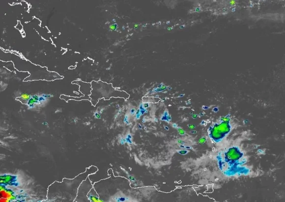
The Dominican Institute of Meteorology (Indomet) has released an updated national weather forecast for Sunday, warning that persistent precipitation will impact multiple provinces across the country. The unsettled conditions are driven by a multi-level tropospheric trough, paired with dominant east and southeast trade winds and localized atmospheric effects that combine to fuel prolonged rain activity.
Early Sunday morning, scattered light showers and isolated intense downpours are projected to hit the northern, northeastern, and southeastern coastal regions, as well as the mountainous Central Cordillera zone. As the day progresses into the afternoon, the weather system is expected to intensify, bringing moderate to heavy locally concentrated downpours. These intense rain events will be accompanied by sudden thunderstorms and strong wind gusts, with the highest impact forecast for 12 key provinces: Monte Plata, northern Santo Domingo, San Pedro de Macorís, La Romana, San Cristóbal, Santiago, Sánchez Ramírez, Hato Mayor, Hermanas Mirabal, Monseñor Nouel, San Juan and Elías Piña, plus adjacent surrounding communities.
In response to the elevated flood risk from the forecast heavy rain, Indomet’s National Forecast Center has issued an official Meteorological Alert covering Greater Santo Domingo and San Cristóbal. The alert warns of a high probability of rapid flash flooding in both urban low-lying areas and rural river basins across the warned region.
Alongside the rain threat, the Dominican Republic will continue to experience unseasonably hot conditions through Sunday. Maximum temperatures are forecast to range between 31°C and 35°C across most of the country’s territory. To help residents stay safe during the heat event, Indomet has issued a series of public health guidelines: maintaining steady hydration by drinking enough water throughout the day, opting for lightweight, loose-fitting clothing in light shades that reflect sunlight, avoiding unprotected exposure to direct sunlight between 11 a.m. and 4 p.m. when UV radiation and heat are at their peak, and staying in cool, well-ventilated spaces as much as possible. The agency also emphasized that children, older adults, and pregnant women face a disproportionately higher risk of heat-related illness, requiring extra care and monitoring from family and community members.
On the topic of Atlantic cyclonic activity, Indomet provided an update that removes one existing threat and flags a low-probability developing system for long-term monitoring. Post-tropical cyclone Isaias is currently positioned approximately 105 kilometers southeast of Nashville, Tennessee in the United States, with maximum sustained winds of 35 kilometers per hour. The system is tracking northeast at a forward speed of roughly 37 kilometers per hour, and its current position and trajectory mean it does not pose any threat to the Dominican Republic’s land or coastal areas.
Separately, meteorologists are tracking an unorganized cluster of rain and thunderstorms linked to a weak low-pressure zone, located around 160 kilometers southwest of the Cape Verde islands off the west coast of Africa. Current forecasting models give the system just a 10% chance of strengthening into a named cyclone over the next 48 hours, rising to a 20% chance of development over the coming seven-day window.
To conclude the official update, Indomet is urging all Dominican residents to remain vigilant, stay connected to the latest official weather updates from the agency, and strictly follow safety guidance issued by national and local civil protection authorities.