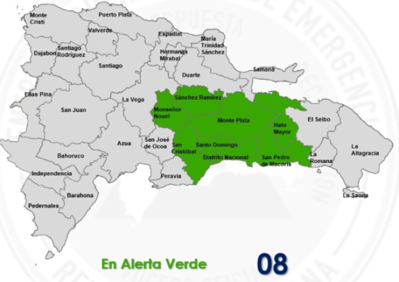
Residents of the Dominican Republic are bracing for a wet and potentially hazardous weekend, after national emergency authorities issued a green alert for seven provinces and the National District in response to a confluence of weather systems set to drive heavy rainfall across the eastern Caribbean nation over coming days.
The Emergency Operations Center (COE), the country’s lead agency for disaster preparedness and response, activated the green alert for eight population centers, including Greater Santo Domingo, the National District, northern San Cristóbal, Monte Plata, Monseñor Nouel, San Pedro de Macorís, Hato Mayor, and Sánchez Ramírez. The alert comes after meteorologists confirmed multiple overlapping atmospheric conditions that will ramp up precipitation across the country starting this week.
Forecasters from the Dominican Institute of Meteorology (INDOMET) explained that a lingering tropical trough positioned near the country, paired with unusually high atmospheric moisture and local geographic effects, will push rainfall intensity upward beginning this afternoon. Through the affected regions, the agency projects scattered moderate downpours, accompanied by rolling thunderstorms and sudden wind gusts that could catch residents off guard.
Unsettled conditions are projected to persist for a full 24 hours after the initial rain event develops. Warm regional surface temperatures, combined with moisture-laden winds flowing in from both the Caribbean Sea and the Atlantic Ocean, will continue to create ideal conditions for shower and thunderstorm formation. A rare lack of dry, airborne Saharan dust — which normally suppresses strong rainfall development across the Caribbean during tropical storm season — has further amplified conditions favorable for heavier, more sustained downpours.
Adding to the precipitation risk is the lingering influence of former Tropical Storm Fay. The storm’s remnants have weakened into a low-pressure system that is currently tracking northeast of the Caribbean basin. As it moves, it will pump additional moisture into the atmosphere over the Dominican Republic, amplifying the effects of the existing trough.
This combination of factors has elevated the risk of disruptive flooding, with COE warning that both urban flash flooding and rural river flooding could occur between Friday and Sunday. To keep residents safe, COE has issued clear safety guidance for communities in the alert zone: authorities have urged people to avoid crossing swollen rivers, streams, and ravines, even if water levels appear passable. They also advised the public to stay away from beaches, rivers, public swimming areas and all other open bodies of water until unstable weather conditions pass and the alert is lifted.