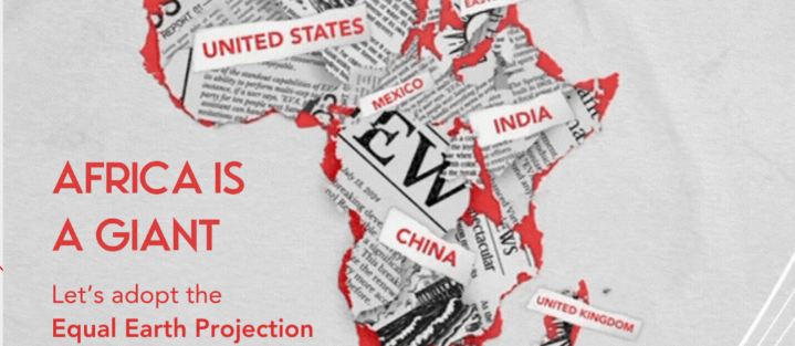
On September 4, at the United Nations headquarters in New York, the UN General Assembly passed a landmark resolution that marks a major shift in global cartographic practice, backing the widespread adoption of world maps that accurately reflect the true size of Africa and other global regions. The vote ended with 164 member nations supporting the measure, only the United States voting in opposition, and six countries choosing to abstain.
This resolution is the culmination of a years-long African-led advocacy campaign called #CorrectTheMap, which has sought to challenge the centuries-long dominance of the deeply inaccurate Mercator projection. Developed in 1569, the Mercator projection systematically distorts land mass size: it makes territories farther from the equator appear far larger than their actual geographic dimensions, while shrinking the apparent size of equatorial and tropical regions, most notably Africa. On a standard Mercator map, Greenland appears roughly the same size as Africa, even though the African continent is 14 times larger than the Greenland ice sheet. Backers of the campaign note that Africa is so vast that it could easily fit the entire land area of the United States, China, India, Japan, Mexico, and most of Europe within its borders, with additional space left over. A public petition on Change.org in support of the initiative gathered more than 11,000 signatures from global supporters.
The movement gained institutional traction in August 2025, when the African Union officially endorsed the #CorrectTheMap initiative and tasked the West African nation of Togo with leading diplomatic efforts to bring the issue to the UN. Togo’s diplomatic team spearheaded the resolution drafting and negotiation process ahead of the General Assembly vote. Ahead of the ballot, Togo’s Foreign Minister Robert Dussey emphasized that maps are far more than simple geographic references: they shape global public education, collective cultural imagination, and how societies perceive global power dynamics.
Advocates of the resolution have hailed the outcome as a historic turning point. Fara Ndiaye, Deputy Executive Director of Senegal-based public health and advocacy group Speak Up Africa, shared that she felt profound joy and slight surprise at the overwhelming support for the measure. Speaking in an interview with France 24, Ndiaye explained that cartography and systems of geographic representation have always been intertwined with global power structures, shaping how communities perceive global influence and presence. She noted that while many alternative, more accurate map projections have existed for decades, the Mercator projection has retained its unchallenged dominance for centuries, meaning the UN’s vote carries clear political weight.
“Choosing a projection is not a technical detail. It’s really, truly, a political act,” Ndiaye stressed. When asked about the significance of former European colonial powers voting in favor of the resolution, she highlighted that this is the first time in history that 164 nations have collectively committed to prioritizing geographic accuracy in global mapping. She commended Togo, Dussey, and all partner organizations for turning the idea of a fairer map into a formal global agreement, echoing Dussey’s core assertion that “a fair world begins with a fair map.”
Crucially, the UN resolution does not ban the Mercator projection or formally mandate that it be replaced by the Equal Earth projection, a popular equal-area design first released in 2018. Instead, the non-binding measure encourages governments, educational institutions, international bodies, and major technology companies to adopt equal-area projections like Equal Earth when illustrating the relative size of continents. It also calls for expanded public education around the inherent challenges of mapping a spherical planet on a flat surface, and the trade-offs between different cartographic approaches.