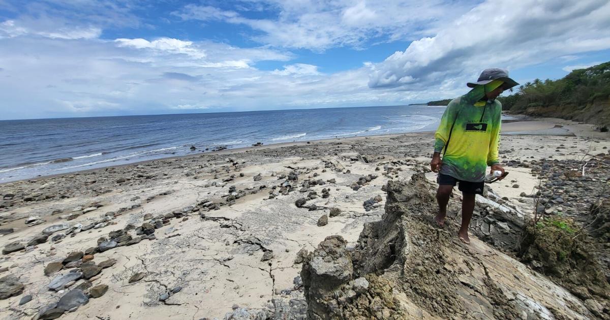
Two of the deadliest earthquakes to hit northern Venezuela in recent memory have left a visible geological mark more than 300 miles away on the southwestern coast of Trinidad, researchers from The University of the West Indies (UWI) Seismic Research Centre (SRC) have confirmed in their first official assessment of the unusual coastal shift. The back-to-back magnitude 7.2 and 7.5 quakes that struck Venezuela last month have killed more than 2,000 people, displaced thousands more as homeless, and left hundreds unaccounted for, with search and rescue operations still ongoing in the hardest-hit La Guaira State. Just days after the large seismic event, residents of Cedros’ Galfa coastline reported a shocking transformation: large stretches of shoreline had lifted nearly instantaneously, leaving hundreds of stranded sea creatures trapped between new rock formations and exposing new sections of previously submerged land.
Initial on-site observations by geologist Xavier Moonan put the maximum elevation gain from the sudden uplift at roughly 20 feet. Moonan also noted unusual natural oil seeps bubbling up through new shallow rippling pools formed by the shifted terrain. In its preliminary analysis released this week, the UWI SRC confirmed that the extreme coastal movement was directly triggered by energy from the Venezuelan twin earthquakes, drawing a parallel to similar geological fracturing that followed a large 6.9 magnitude quake near Trinidad in 2018.
Trinidad’s southern coast sits atop a major east-west geological formation called the Southern anticline, a folded rock system crisscrossed by active faults, the SRC explained. This structure creates a linear geological corridor along the south coast that allows pressurized water, oil, and gas trapped deep below the surface by tectonic plate movement to rise toward the crust, resulting in a dense concentration of mud volcanoes across the region.
Mud volcano formations are defined by fluid-saturated substrate close to the surface, which gives the surrounding ground very low shear wave velocities. Because shear waves—one of the primary types of seismic energy generated by earthquakes—travel far slower through softer, less compact rock and sediment, these geologically unique areas become far more sensitive to shaking from large distant earthquakes, the research team noted.
The two Venezuelan quakes occurred along the same interconnected fault system, shared nearly identical focal mechanisms, and struck within minutes of one another, meaning they can effectively be treated as a single massive seismic event that produced more than 10 minutes of continuous shaking across the region. Testing at the L’Envieuse mud volcano near Icacos, just west of Cedros, found the natural fundamental vibration frequency of the local geology before the quake was exactly half the frequency of the seismic waves from the Venezuelan earthquakes. This resonance effect amplified the shaking energy, reactivating subterranean mudflows and triggering the sudden coastal uplift seen in Galfa.
“These unique geological responses are to be expected on Trinidad’s south coast and other regions with similar geology after large magnitude seismic events,” the SRC assessment noted. “As such, targeted efforts must be made to mitigate future risk to lives and livelihoods located in these geologically susceptible areas.” The center plans to release a full, comprehensive report after completing additional on-site testing and data analysis.
This is not the first time large seismic activity has triggered extreme coastal and land movement in Cedros. In August 2018, a 6.9 magnitude quake centered off Trinidad’s coast caused widespread infrastructural damage across the island, with tremors felt as far away as Barbados, Guyana, St Lucia, and Venezuela. In Cedros, the shaking fractured large sections of land, crumpled key roadways, and cut off dozens of farmers participating in a local food production project from their agricultural plots in the Los Iros area. Farmers reported massive ground cracks that swallowed farming equipment, destroyed crop fields and livestock storage structures, and drained local ponds. Just one year ago, renewed activity at the nearby Los Iros mud volcano triggered a similar coastal uplift at the local beach, pushing some sections of shoreline up as long as 20 feet. That event left key agricultural routes impassable during peak farming season and caused thousands of dollars in lost crop and infrastructure damage for local producers, according to on-the-ground reports from environmental activists and farmers.