As the 2026 Atlantic hurricane season approaches, the U.S. National Oceanic and Atmospheric Administration (NOAA) has released its official seasonal outlook, projecting a lower-than-average number of storm systems for the coming six-month period. Even with this milder projection, however, federal weather officials are emphasizing that coastal and at-risk communities cannot afford to lower their guard, stressing that a single powerful hurricane can still cause catastrophic damage to life and infrastructure.
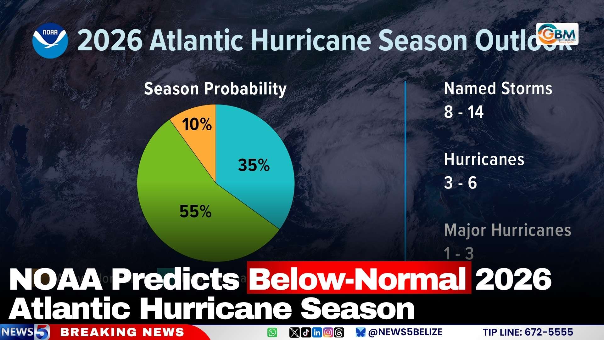
The Atlantic hurricane season follows a fixed official timeline, running from June 1 through November 30 each year. NOAA’s climate analysis puts the probability of a below-normal season at 55%, with a 35% chance of activity matching long-term average levels, and just a 10% chance of an above-normal season that brings more frequent or intense storms than usual.
Breaking down the projected storm counts, NOAA forecasts that between 8 and 14 named storms will develop across the Atlantic basin in 2026. Of these organized systems, 3 to 6 are expected to strengthen into full hurricanes, and 1 to 3 will intensify into major hurricanes — classified as systems with sustained wind speeds exceeding 111 miles per hour.
To improve the reliability of storm tracking and public alerts, NOAA and its partner agency the National Weather Service have upgraded their forecasting infrastructure for this season. The agencies are integrating cutting-edge tools including artificial intelligence-powered weather modeling, specialized observation drones, and data from next-generation weather satellites, all designed to deliver faster, more accurate warnings that give communities more time to prepare and protect lives and property.
Meteorologists point to the anticipated development of El Niño climate patterns as the primary driver behind the projected slowdown in hurricane activity. El Niño, characterized by elevated ocean surface temperatures in the central and eastern Pacific, typically generates increased wind shear across the Atlantic basin that disrupts the formation and strengthening of tropical cyclones. Even so, forecasters note that two key factors — slightly warmer-than-average Atlantic sea surface temperatures and weaker than usual trade winds — still create favorable conditions for some storm development this season.
A critical note from NOAA: the seasonal outlook only provides a broad prediction of overall activity across the entire Atlantic basin, and cannot forecast how many storms will make landfall in specific regions. Details on individual storm tracks and landfall risks depend on short-term weather conditions that emerge over the course of the season, underscoring the need for all at-risk communities to have emergency plans in place regardless of the seasonal outlook.