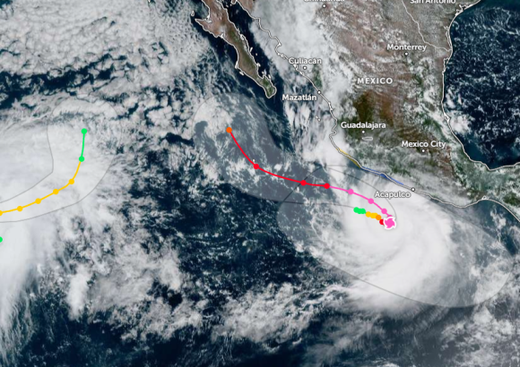
On September 22, a dangerous weather event unfolded off Mexico’s southwestern Pacific shoreline, when Hurricane Polo completed an extraordinary and rapid intensification surge to reach Category 5 status — the highest ranking on the Saffir-Simpson hurricane intensity scale. What began as a moderate Category 1 hurricane ballooned into a catastrophic Category 5 storm in less than 24 hours, a speed of strengthening that has become increasingly common amid warmer ocean temperatures linked to climate change.
As of Tuesday, the National Hurricane Center (NHC) and Mexico’s National Meteorological Service (SMN) were tracking the powerful system around the clock. The storm had already registered maximum sustained winds of roughly 260 kilometers per hour (160 miles per hour), with even more powerful gusts that can cause catastrophic damage to infrastructure. At the time of monitoring, Polo was positioned south of two major coastal destinations: Zihuatanejo in the state of Guerrero and Manzanillo in Colima. Though the storm’s center remained offshore, a tropical storm warning remained active for a long stretch of Mexico’s southwestern coast, keeping local communities on high alert.
National and state officials have issued urgent warnings about the range of life-threatening hazards the storm will bring to multiple coastal states, including Guerrero, Michoacán, Colima, Oaxaca and Jalisco. Even with the storm’s core staying over open ocean, its large atmospheric circulation is projected to push dangerous conditions onshore, including torrential downpours, damaging sustained winds, extreme high surf, widespread flash flooding and deadly landslides across mountainous and low-lying coastal areas.
In a proactive precautionary move, education authorities in Guerrero and Michoacán announced the immediate suspension of all classes across both states on September 22 and 23, moving instruction online and closing campuses to protect students and staff. To further bolster response capacity, Mexico’s Federal Electricity Commission pre-deployed emergency response teams, specialized utility vehicles, portable backup generators and a full suite of storm recovery equipment to high-risk regions, positioning crews to restore power quickly in the event of widespread outages.
Meteorologists continue to emphasize that the storm’s track could shift closer to shore in the coming days, urging residents in all watch areas to stay tuned to official updates and follow evacuation orders if issued by local authorities.