On September 8, the United Nations General Assembly took a landmark step to address centuries of geographic bias in global mapping, approving a resolution led by African nations that encourages member states to adopt the Equal Earth map projection — a alternative that corrects the size distortions that have minimized the Global South on traditional maps for hundreds of years.
The resolution, which won backing from 164 member states, faces only one opposing vote from the United States, with six Eastern European nations — Serbia, Estonia, Georgia, Lithuania, Moldova, and Ukraine — abstaining from the vote. The core goal of the measure is to promote a more geographically accurate representation of the world’s continents, replacing the widely used Mercator projection, which was originally developed in 1569 by Flemish cartographer Gerardus Mercator for maritime navigation.
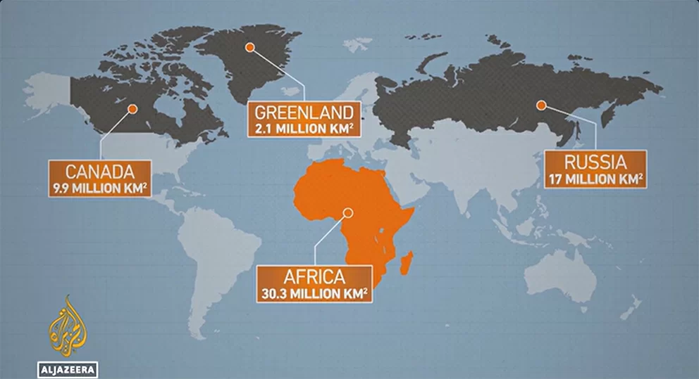
For centuries, the Mercator projection’s design has skewed public perception of global landmasses. Created to preserve straight lines for ocean navigation, it exaggerates the size of land masses closer to the poles while shrinking territories near the equator. This distortion leaves northern, wealthier regions appearing far larger than they actually are relative to equatorial and southern nations. For example, on Mercator maps, Africa appears roughly the same size as Greenland, but in reality, Africa is 14 times larger than the Arctic island. In actual area, Africa spans 30.3 million square kilometers — large enough to fit the entire United States, China, India, and most of Europe within its borders. Combined, the four regions disproportionately shrunk by Mercator — Africa, Latin America, South Asia, and Oceania — cover more than 64 million square kilometers, over 40% of the world’s total land area. By contrast, the entire continent of Europe only measures 10.2 million square kilometers.
The Equal Earth projection, launched in 2018 by three cartographers from the Environmental Systems Research Institute, U.S. National Park Service, and Australia’s Monash University, fixes this long-standing bias. Co-creator Bojan Savric explained in a 2025 interview with AFP that the projection preserves the relative size of all continents while retaining accurate representations of their shapes, matching how landmasses appear on a three-dimensional globe.
Togo’s Foreign Minister Robert Dussey, whose country led the resolution effort, emphasized that maps are far more than navigational tools. “Maps shape education, fuel public imagination, and shape collective global perceptions,” he said, adding that the adopted resolution “affirms the African reality” that has been erased and minimized for centuries.
Reactions to the resolution have been largely positive among supporting nations. France, a co-sponsor of the text, has already announced it will abandon the Mercator projection for official use. French Foreign Minister Jean-Noel Barrot noted that the traditional projection gives the U.S., Russia, and China “disproportionate visual dominance over Africa, Latin America, or Southeast Asia,” while perpetuating the false illusion that Greenland is nearly as large as Africa. “Changing maps will not change the world on its own,” Barrot said. “But correcting a distorted representation is already an act of truth.”
The resolution faced sharp criticism from the U.S. delegation. U.S. representative Yaryna Ferencevych argued that the debate over 16th-century map projections distracts the UN from addressing pressing global issues, claiming the resolution is evidence the body “is losing its credibility.”
Notably, the UN resolution is not legally binding for member states. The world body has stressed it does not ban the Mercator projection or mandate a universal replacement, and instead only encourages governments and international institutions worldwide to adopt the Equal Earth projection as a new standard for more accurate geographic representation.