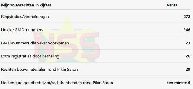
A newly released government dataset of mining concessions submitted to Suriname’s National Assembly (DNA) has revealed key details about the distribution and scale of mineral extraction rights across the country, after independent fact-checking and data cleaning by local outlet Starnieuws corrected duplicate entries in the original document.
When first published, the 14-page dataset logged 272 separate entries for mining concessions. But when Starnieuws cross-referenced each entry by its unique GMD identification number, the outlet found 23 GMD numbers repeated across overlapping lists, resulting in 26 duplicate entries. After cleaning, the final count stands at 246 fully unique, active and expired mining concessions covering a wide range of mineral and raw material activities across Suriname. The full dataset includes core details for each concession: the name of the rights holder, GMD identification number, type of mining right, total concession area, and in most cases, the issuance and expiration dates of the permit.
Gold extraction dominates the list of concessions, with operations spanning the full spectrum from large-scale exploration and commercial mining to small-scale artisanal gold mining. The scale of these gold concessions varies dramatically: most small-scale gold permits cover roughly 200 hectares, while large exploration concessions held by major operators can span thousands of hectares, with some exceeding 10,000 hectares in total area.
The dataset also enables new analysis of how mining rights are concentrated. Beyond counting the total number of concessions, it allows researchers and regulators to track how many rights are held by individual operators and the total area they control — a key metric, given that one large exploration concession can cover more territory than dozens of small-scale permits combined.
The region surrounding Pikin Saron emerges as a major hub of mining activity in the dataset. Multiple gold exploration and extraction concessions, both active and expired, are held by major mining firms operating in the area, including Rosebel Gold Mines N.V., Grassalco N.V., Consolidated Gold Resources N.V., Capital Gold Eagle Mining N.V., Suku Passie N.V. and Agnesia Mijnbouwonderneming N.V. The size of these large-scale concessions is striking: Rosebel Gold Mines holds a 10,768-hectare exploration permit, Grassalco holds 10,450 hectares, Consolidated Gold Resources holds 13,761 hectares, and Capital Gold Eagle Mining holds 2,570 hectares. The records confirm that the Pikin Saron region has hosted far more large-scale mining activity than the small-scale operations that are most visible to the public.
Beyond gold, the dataset lists 29 unique concessions for construction raw materials in Pikin Saron alone, primarily for savanna sand, laterite, and fill sand, with one concession covering combined sand, gravel and laterite extraction. This confirms multiple types of resource extraction operate side-by-side across the region.
The release of this detailed concession data takes on new urgency following a major mass fish mortality event earlier this year in the Moeroe Creek and along the Saramacca River, which sparked widespread public concern that mining activity and the use of toxic chemicals had caused toxic contamination. The extensive footprint of active and expired mining rights in the region raises pressing questions about the effectiveness of environmental regulatory oversight: with multiple types of gold exploration, extraction and construction material mining operating in proximity, regulators need clear data on which operators are active, what environmental rules apply to each concession, and how compliance with those rules is enforced.
Importantly, the dataset itself does not draw a causal link between any listed concession holder and the fish mortality event. The document only records the existence of mining rights and their holders, and does not assign blame or legal liability for the environmental incident. Analysts emphasize this distinction must be made clear: the dataset does not prove any operator caused the mortality event, but it does highlight why rigorous, targeted investigation of activity in the region is necessary. A list of concession rights only shows who holds permission to extract resources, not which operators are actively working at a given time, or whether unauthorized extraction is occurring outside permitted concession boundaries.
With the release of the full concession dataset, the next critical step for analysis is mapping how rights are distributed across holders. Multiple individuals and companies appear repeatedly across the dataset, and analysts plan to sort the 246 unique concessions by rights holder, as well as by commodity, to determine how many rights each entity holds, what total area they control, how many of those rights remain active, and the extent to which Suriname’s mining rights are concentrated among a small group of actors.
Far from being just a list of names and numbers, the government’s submission to DNA provides a foundational public resource to map who has access to Suriname’s vast mineral wealth, how much territory has been allocated for extraction, and how those rights have been distributed over decades of mining development. Starnieuws announced it will continue its in-depth analysis of the concession data as part of its ongoing *Gold dossier* investigative series focused on reform and transparency in Suriname’s mining sector.