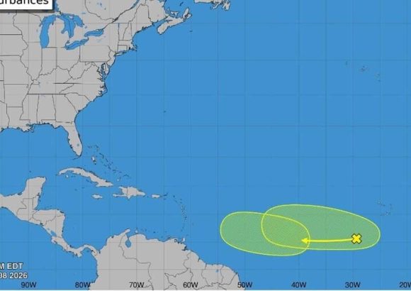
As August ushers in the most dangerous phase of the annual Atlantic hurricane cycle, the top official of the Dominican Republic’s national meteorological agency has sounded a public alert over rising storm activity in the basin, alongside ongoing impacts from transcontinental dust transport shaping local weather this weekend.
Gloria Ceballos, director of the Dominican Institute of Meteorology (Indomet), shared the update Saturday, noting that the Atlantic basin is showing early signs of increased storm formation just as the season enters its historically most active window. “It’s August, we’re stepping into the peak of the hurricane season, and the Atlantic is beginning to stir,” Ceballos stated, referencing two tropical waves that Indomet’s forecasting teams have been tracking closely for potential development into cyclonic systems over the coming week.
Ceballos emphasized that right now, both monitored systems carry only a low probability of consolidating into named storms or hurricanes. As the systems drift westward toward the Caribbean basin, they are expected to encounter atmospheric and oceanic conditions that are hostile to cyclonic growth. Still, the agency has committed to continuous monitoring to update the public on any changes in trajectory or intensity. “We will follow their evolution step by step, even if current conditions do not favor development,” Ceballos added.
Beyond the long-term monitoring of tropical systems, Indomet also released its on-the-ground weather forecast for Dominican territory this Saturday, noting that the country remains under the blanket of a denser-than-usual plume of Saharan dust. This airborne dust layer has suppressed large-scale cloud formation, preventing the build-up of significant moisture that would lead to heavy, widespread rainfall across most of the country.
The forecast calls for minimal precipitation and sweltering high temperatures across the majority of the Dominican Republic for the day. Even so, Indomet did not rule out isolated, short-lived weather events through the afternoon and early evening. A combination of persistent easterly trade winds, daytime surface heating, and the region’s mountainous topography could trigger localized increases in cloud cover.
Those conditions are expected to produce scattered, short downpours and isolated thunderstorms primarily across the central and northwestern regions of the country, including the provinces of Monte Plata, Santo Domingo Norte, La Vega, Monseñor Nouel, San Cristóbal, Sánchez Ramírez, San Juan, Elías Piña, and Dajabón, as well as adjacent surrounding areas.