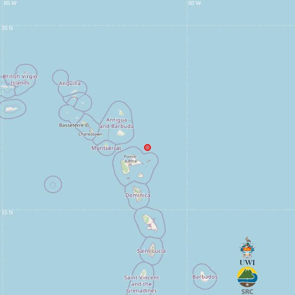
The University of the West Indies Seismic Research Centre (UWI-SRC) has documented a light magnitude 3.8 earthquake that struck the eastern Caribbean on the morning of Tuesday, October 27, with no immediate public reports of structural harm or resident accounts of feeling the tremor released as of the initial public notice. Seismic monitoring logs show the tremor registered at exactly 8:29 a.m. local time, originating at a shallow depth of just 10 kilometers below the ocean floor. The preliminary automated location calculation places the quake’s epicenter roughly 97 kilometers southeast of St. John’s, the capital city of Antigua and Barbuda, with pinpoint coordinates marked at 16.69 degrees north latitude and 61.08 degrees west longitude. Cross-referencing this preliminary placement puts the seismic event also around 70 kilometers northeast of Pointe-à-Pitre, the largest city in Guadeloupe, and approximately 126 kilometers east of Brades, the de facto administrative capital of Montserrat. UWI-SRC officials emphasized that the geographic coordinates released in the initial alert were generated in real time by automated seismic processing algorithms, and the data team of certified seismologists is currently conducting a manual review of raw sensor readings to refine and potentially adjust the exact epicenter location in coming updates. The centre’s public advisory did not include any confirmation that the low-magnitude tremor was felt by coastal communities across the nearby island territories, nor did it note any reports of property damage, infrastructure disruption, or injury tied to the event at the time of publication.