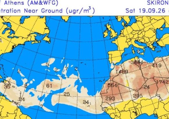
SANTO DOMINGO – After days of widespread rainfall across the Dominican Republic driven by a tropical wave and upper-level trough, the primary weather systems that brought heavy precipitation have moved out of direct influence over the Caribbean nation, leaving only residual moisture to trigger isolated downpours in inland regions. According to Cristopher Lorian, a leading meteorologist with the Dominican Institute of Meteorology (Indomet), ongoing residual rain activity is currently concentrated in specific zones, including Santiago Rodríguez, the southern districts of the Santiago province, and the elevated mountainous regions of La Vega. Lorian notes that these scattered rain events, which can come paired with sudden thunderstorms and strong wind gusts, are projected to shift across other parts of the Cibao region through Saturday afternoon, covering Puerto Plata, Valverde, Dajabón, and their adjacent surrounding areas. Moving into the weekend, three overlapping atmospheric conditions will reshape the country’s weather pattern. A lingering humid air mass will remain in place, while moderate concentrations of Saharan dust will drift into the region, all under the stabilizing influence of an upper-level anticyclonic system. This combination will drastically restrict rainfall across the nation, limiting both the total volume of precipitation and the geographic area that will see any rain at all. “Rain will be restricted to far fewer provinces, and any showers that do develop will be light in intensity,” Lorian explained. “Most of the country will experience mostly sunny skies, though a hazy gray tint will hang over the atmosphere due to the incoming Saharan dust, which begins arriving tomorrow.” The combination of residual humidity, Saharan dust, and limited cloud cover will push perceived temperatures higher across the entire Dominican Republic, driving the heat index to uncomfortable levels in most areas. Weather projections indicate this warm, dry, hazy pattern will hold through the entire extended weekend into early next week. Conditions on Sunday will mirror those on Saturday, with the same warm, limited-rain profile expected to continue through Monday and Tuesday. While a weak trough is forecast to move near the nation during this period, atmospheric moisture levels will remain far too low to trigger widespread significant rainfall.
Rainfall will decrease across the country starting this Saturday