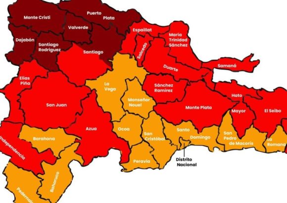
The Dominican Republic is currently grappling with a sustained spell of record-breaking extreme heat, and official forecasts confirm that the sweltering conditions will not abate in the near term. According to updated projections from the United States National Oceanic and Atmospheric Administration (NOAA), the entire country will remain under an official extreme heat warning until at least July 14.
This warning was confirmed to local outlet HOY by Saddan Font-Frías, an engineer and Master of Science who leads the Meteorological Research Department at the Dominican Institute of Meteorology (INDOMET). Font-Frías emphasized that this is no temporary warm spell, but a long-duration extreme heat event that poses tangible risks to public health and critical infrastructure.
Data from INDOMET shows that between July 1 and July 7, there is a very high likelihood that the combined maximum temperature and heat index will remain above 33 degrees Celsius for three or more straight days. The hardest-hit regions are expected to be the country’s northern, northwestern, and large swathes of its central interior, where conditions will be most severe.
Climate model projections analyzed by INDOMET indicate this abnormal heat pattern will persist through the second week of July, from July 8 to July 14, solidifying what experts are calling one of the longest prolonged heat events the country has faced in recent years.
Font-Frías warned that consecutive days of extreme heat create unique public health dangers that are not present in short warm spells. When the body cannot cool down overnight between hot days, it builds up cumulative heat stress, with little time to recover. This drastically raises the risk of serious heat-related illnesses including heat exhaustion and life-threatening heat stroke, he explained.
Meteorologists have identified a combination of overlapping atmospheric conditions driving this prolonged heat event. Trade winds have been consistently pushing warm, moisture-heavy air from the Atlantic Ocean and Caribbean Sea over Dominican territory. On top of that, a persistent high-pressure system is sitting in the mid-levels of the atmosphere, paired with a process called atmospheric subsidence, where air sinks from upper atmospheric layers down to the surface.
“When descending air compresses, it warms up significantly. This process acts like an atmospheric lid that traps heat near the ground, blocks the formation of tall, rain-bearing clouds, and allows unfiltered solar radiation to continue heating the surface,” Font-Frías explained. The combination of elevated baseline temperatures, high humidity, and minimal rainfall pushes the heat index to dangerous levels that far outpace what standard temperature readings would suggest.
Forecasts from NOAA also show there is a more than 50% chance that total precipitation over the coming weeks will stay well below the long-term average for this time of year, creating a cascading set of challenges for the country. The dual pressure of high heat and low rain creates a two-pronged crisis, according to Font-Frías: soaring temperatures drive increased demand for water and electricity as people rely on cooling, while reduced rainfall shrinks available water supplies and puts additional stress on agricultural crops across the country.
“This scenario demands that all residents practice intentional, responsible water use, and that public agencies maintain constant, close monitoring of evolving weather and infrastructure conditions,” he said. The expert added that the current heat event has been exacerbated by another recurring seasonal factor: near-constant presence of Sahara dust air masses over the country. These dust-laden air masses further dry out the local environment, reduce cloud formation, and allow even more solar radiation to reach the surface, amplifying the already extreme heat.
Public health officials are urging residents to stay hydrated, avoid prolonged outdoor activity during peak heat hours, and check on vulnerable community members including the elderly and those without access to consistent cooling as the event continues through mid-July.