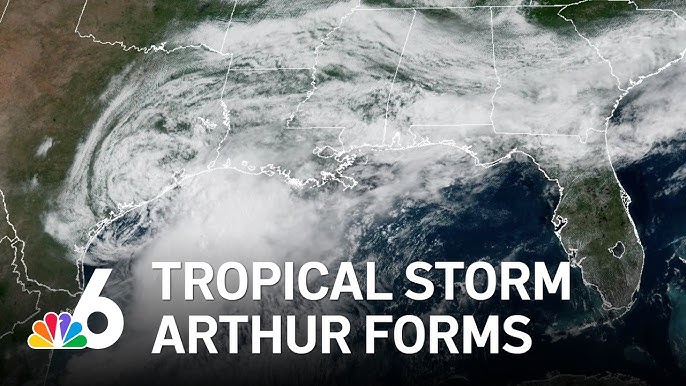
The 202X Atlantic hurricane season has gotten an early start, with Tropical Storm Arthur officially forming on Wednesday off the Texas Gulf Coast to become the season’s first named tropical system, according to updates from the U.S. National Hurricane Center (NHC).
Meteorologists logged the storm’s formation roughly 40 miles off the coast of Port O’Connor, Texas, and around 190 miles southwest of Lake Charles, Louisiana. As of initial observations, Arthur is tracking northeastward, packing maximum sustained winds of 40 miles per hour — just hitting the 39 mph threshold required to classify a tropical system as a named tropical storm.
Forecasters project Arthur will gain little additional intensity as it approaches and potentially makes landfall along the U.S. Gulf Coast. The storm is expected to accelerate through Wednesday, with its center tracking either along the Texas coastline or moving inland before it pushes into southern Louisiana. After turning further inland, the system is predicted to gradually weaken, per NHC projections.
No matter the exact track Arthur takes, officials have issued urgent warnings that the system will deliver extreme rainfall and widespread flooding across a large swath of the U.S. Southeast, stretching from the major metro area of Houston, Texas, all the way east to Atlanta, Georgia. In official advisory updates, forecasters emphasized the storm is expected to trigger life-threatening flash flooding and damaging wind gusts across multiple parts of the region.
Public safety officials have activated tropical storm warnings covering the stretch of coast from High Island, Texas, eastward to Morgan City, Louisiana. Under this warning level, tropical storm conditions are confirmed to arrive within the next 12 hours in these zones. A separate tropical storm watch remains in effect for the Texas coast from Sargent to High Island, where tropical storm conditions are possible but not certain within the same 12-hour window.
Arthur emerged from a tropical disturbance that began organizing earlier this week in the western Gulf of Mexico. Its development comes as coastal communities already in its path have been grappling with repeated rounds of heavy rainfall that have already sparked dangerous flash flooding across several U.S. states.
The storm is projected to drop a total of 5 to 10 inches of rain across large parts of Texas, Louisiana, Mississippi, Alabama, and the western reaches of Florida’s Panhandle. NHC also warned that storm surge could push coastal water levels as much as 4 feet above normal in typically dry coastal zones, with the exact height depending on the timing of high tide.
“The deepest inundation will be concentrated along the immediate coast near and to the east of where Arthur makes landfall, where the storm surge will be paired with large, hazardous breaking waves,” the NHC explained in its advisory. The agency added that the system will also create life-threatening surf and rip current conditions along the northwestern Gulf Coast over the next 48 hours, and isolated tornadoes cannot be ruled out across coastal and inland parts of the region.
The official Atlantic hurricane season runs annually from June 1 through November 30, though the bulk of tropical activity typically peaks between August and October. Ahead of this year’s season, the U.S. National Oceanic and Atmospheric Administration (NOAA) released its latest seasonal outlook, forecasting below-average storm activity. NOAA projects the 202X season will see between 8 and 14 named storms, 3 to 5 of which are expected to strengthen into full hurricanes.