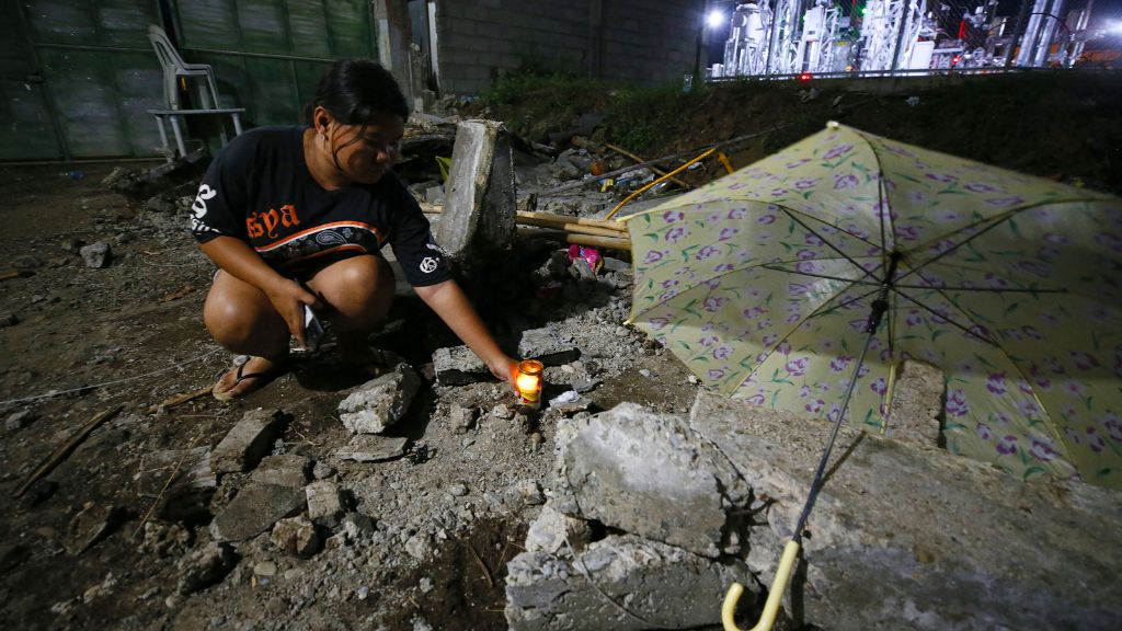
The southern Philippines was struck by two powerful earthquakes on Friday, resulting in at least eight fatalities and widespread panic. The initial quake, measuring 7.4 in magnitude, occurred approximately 20 kilometers off the coast of Manay town in the Mindanao region at around 10 am local time, as reported by the United States Geological Survey. A significant aftershock of magnitude 6.7 followed nearly 10 hours later, compounding the devastation. These seismic events came just 11 days after a 6.9-magnitude earthquake in Cebu province claimed 75 lives and injured over 1,200 people. Among the victims were three miners who perished in a tunnel collapse west of Manay during the initial quake. Rescue efforts saved one miner, while several others sustained injuries. In Mati city, one individual died from a collapsing wall, and two others succumbed to heart attacks. Davao city, located over 100 kilometers from the epicenter, reported another fatality due to falling debris. Philippine authorities issued tsunami warnings following both quakes, prompting evacuations along the eastern seaboard. However, no significant waves were observed, and the Pacific Tsunami Warning Center lifted its alert by noon. The tremors caused minor structural damage, landslides, and bridge cracks, leading to the evacuation of over 200 patients from Manay district hospital. Classes were suspended, and non-essential workers were sent home. The Philippines, situated on the Pacific ‘Ring of Fire,’ frequently experiences seismic activity. The 1976 Mindanao earthquake, which triggered a deadly tsunami, remains the country’s worst natural disaster.
分类: world
-

Brace for unstable weather conditions this weekend — Met Service
KINGSTON, Jamaica — The Meteorological Service of Jamaica has issued a weather advisory, warning residents to prepare for rainy conditions as a broad trough sweeps across the western Caribbean this weekend. The weather system is expected to linger over the region for several days, bringing unstable weather patterns to Jamaica and neighboring countries.
-

NODS urges Residents to complete preparedness plans ahead of Tropical Storm Jerry
The Antigua and Barbuda Meteorological Office has issued a Tropical Storm Warning for Barbuda as Tropical Storm Jerry shifts closer to the island. Residents are urged to finalize their hurricane preparedness plans immediately, as sustained tropical storm-force winds are expected within the next 12 to 18 hours. While the warning specifically targets Barbuda, a Tropical Storm Watch remains in effect for Antigua and the broader Leeward Islands. The National Office of Disaster Services (NODS) is closely monitoring the situation and advises residents to stay updated through local media channels. Emergency kits should include essential supplies such as non-perishable food, water, first aid items, flashlights, and medications. Additionally, securing homes, businesses, and agricultural equipment is critical. NODS has also warned against walking or driving through floodwaters, which can pose severe risks. The Met Office emphasizes that tropical storm conditions may extend farther south than currently projected, underscoring the need for vigilance and readiness.
-
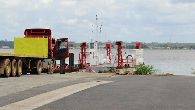
Veerverbinding Albina–St. Laurent ligt stil: reparatie La Gabrielle kan lang duren
The ferry service connecting Albina, Suriname, and St. Laurent, French Guiana, has been temporarily suspended due to a technical malfunction. The service, traditionally operated by the French ferry La Gabrielle, has been halted following damage to its propeller. The defective propeller has been transferred to the Suriname Dock and Shipbuilding Company (SDSM) for repairs. According to NV Havenbeheer Suriname, the repair process is expected to take approximately two weeks, provided the propeller can be fixed. However, if a replacement is required, the suspension could extend up to four months. This disruption follows recent issues, including the ferry’s earlier withdrawal due to the captain’s illness. The suspension has raised concerns among passengers and businesses reliant on cross-border trade, as alternative transportation methods are costlier and riskier. Efforts are underway to deploy the new ferry Le Malani as a temporary solution, but it awaits full approval from French authorities, which could take up to six months. Additionally, reports of shallow waters and debris near the Surinamese docking area have prompted inspections by the Suriname Maritime Authority. While these conditions are not the cause of the current suspension, measures are being taken to address potential obstacles. The ferry service is crucial for the economic and social connectivity of the region, and authorities are working to resume operations swiftly. The Surinamese Ministry of Foreign Affairs is collaborating with French officials to seek a long-term solution.
-
The government of Antigua and Barbuda has issued a Tropical Storm Warning for Barbuda
Tropical Storm Jerry is rapidly approaching the northern Leeward Islands, prompting urgent warnings from meteorological authorities. As of 1100 AM AST, the storm was located near latitude 15.9 North, longitude 59.1 West, approximately 310 miles east-southeast of the region. With maximum sustained winds of 65 mph and a westward-northwest movement at 18 mph, Jerry is expected to pass near or northeast of the northern Leeward Islands later today and tonight. The government of Antigua and Barbuda has issued a Tropical Storm Warning for Barbuda, indicating that tropical storm conditions are imminent within the next 12 hours. Additionally, a Tropical Storm Watch is in effect for Antigua, Anguilla, St. Kitts, Nevis, Montserrat, St. Barthelemy, St. Martin, Sint Maarten, Saba, St. Eustatius, Guadeloupe, and adjacent islands, signaling possible storm conditions within 48 hours. Jerry is forecasted to strengthen in the coming days, potentially reaching hurricane status by late Friday or Saturday. The storm is expected to bring heavy rainfall, with 2 to 4 inches anticipated across the Leeward and Virgin Islands, and isolated totals up to 6 inches. This poses a significant risk of flash flooding, particularly in urban areas and steep terrain. Swells generated by Jerry are already affecting the Leeward and Windward Islands, with life-threatening surf and rip current conditions expected to spread westward. Residents are urged to monitor updates from their national meteorological services and prepare for hazardous weather. The next advisory will be issued at 2:00 PM AST, followed by a complete update at 5:00 PM AST.
-

WEATHER (8:00 AM, October 8): Shower and thunderstorm activity, gusty winds expected today as TS Jerry approaches
As Tropical Storm Jerry advances, regions in its path are bracing for severe weather conditions. The storm, currently positioned near latitude 15.7°N and longitude 58.4°W, approximately 195 miles east of Dominica, is moving west-northwest at 20 mph. With maximum sustained winds of 65 mph and a minimum central pressure of 999 mb, Jerry is expected to intensify into a hurricane by late Friday or Saturday. The storm’s trajectory suggests it will pass near or northeast of the northern Leeward Islands later today and tonight, bringing heavy rainfall of 2 to 4 inches and gusty winds. Coastal areas are particularly vulnerable, with waves reaching up to 8 ft on the west coast and 12 ft on the east coast. A smallcraft warning and high surf advisory have been issued, urging sea users and coastal residents to remain vigilant. Authorities are advising residents in flood-prone zones, landslide areas, and regions susceptible to falling rocks to exercise extreme caution. Loose objects should be secured to prevent them from becoming projectiles in strong winds, and broken branches should be monitored. The public is encouraged to stay updated on the storm’s progress and take necessary precautions to safeguard life and property.
-
Tropical Storm Jerry Warning To Be Issued for Barbuda as System Shifts Closer
Weather authorities have escalated Barbuda’s Tropical Storm Watch to a Tropical Storm Warning as Tropical Storm Jerry alters its trajectory slightly westward, positioning the storm closer to the island than initially projected. The warning, issued at 11 a.m. on Thursday, indicates that sustained tropical-storm-force winds are anticipated within the next 12 to 18 hours. Residents are strongly advised to finalize all storm preparations promptly and prepare for worsening conditions later in the day. Meanwhile, a Tropical Storm Watch remains active for Antigua and the broader Leeward Islands, where tropical storm conditions could still materialize if Jerry’s path veers further south. Meteorologists warn that the storm’s revised course heightens the risk of heavy rainfall, powerful winds, and turbulent seas across the northern Leeward Islands. Authorities urge the public to stay informed through official updates from the Antigua and Barbuda Meteorological Service and the National Office of Disaster Services (NODS) as the situation evolves.
-

Antigua and Barbuda to Lead Crucial Global Climate Science Negotiations
Antigua and Barbuda is poised to play a pivotal role in global climate diplomacy as Arry Simon, a senior official from the Department of Environment, has been appointed to lead the Alliance of Small Island States (AOSIS) and CARICOM in high-stakes science negotiations. These discussions will take place at the 63rd Session of the Intergovernmental Panel on Climate Change (IPCC-63) in Lima, Peru, and during the 30th Conference of the Parties (COP30) in Belém, Brazil. The talks are expected to shape the next decade of global climate action, with a focus on aligning the IPCC’s Seventh Assessment Report (AR7) with the Second Global Stocktake (GST2) under the Paris Agreement. However, this alignment has faced resistance from several major carbon-emitting nations. Simon, a seasoned negotiator with extensive experience in UNFCCC processes, emphasized the challenges ahead. ‘We are entering a critical phase where evidence-based policymaking is under scrutiny,’ he stated. ‘Our role as Small Island Developing States is to defend the integrity of science and ensure global climate ambition is grounded in the best available evidence.’ Observers highlight that these negotiations will determine how scientific findings are integrated into future climate targets, financing frameworks, and adaptation strategies. For vulnerable island nations like Antigua and Barbuda, the outcomes are of existential importance. Under Simon’s leadership, the AOSIS Science delegation will advocate for the independence and continuity of the IPCC process while ensuring the next assessment cycle delivers timely, policy-relevant insights to guide the implementation of the Paris Agreement. As the world approaches COP30, a landmark event marking the midpoint to 2030, the alignment of science and policy will be crucial in determining whether global efforts to limit warming to 1.5°C remain on track.
-
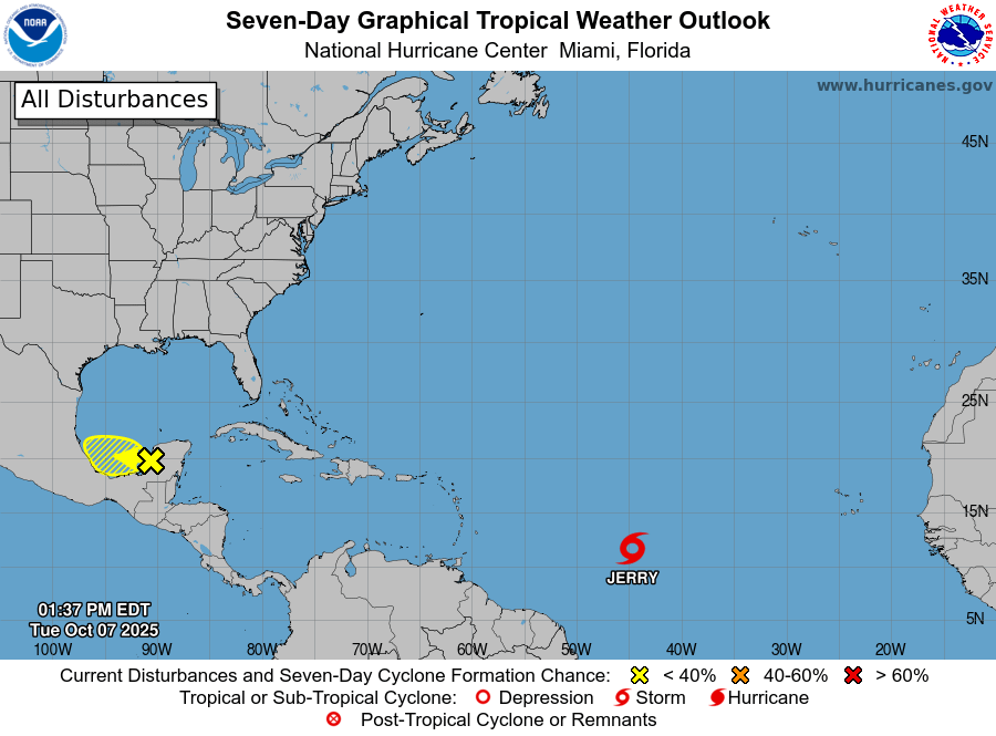
Tropical Storm Watch Remains in Effect for Antigua and Barbuda
Tropical Storm Jerry is rapidly gaining strength as it advances toward the northern Leeward Islands, posing significant risks to the region. According to the National Hurricane Center’s 5 a.m. advisory on October 9, 2025, the storm is moving west-northwest at 20 mph (31 km/h) and is currently located approximately 395 miles (640 km) east-southeast of the islands. With maximum sustained winds of 65 mph (100 km/h), Jerry is expected to intensify further, potentially reaching hurricane status by late Friday or Saturday. A Tropical Storm Watch is in effect for Antigua, Barbuda, Anguilla, St. Kitts, Nevis, Montserrat, St. Barthelemy, St. Martin, Sint Maarten, Saba, St. Eustatius, Guadeloupe, and nearby islands. The storm’s center is forecasted to pass near or northeast of the northern Leeward Islands later today, bringing heavy rainfall of 2 to 4 inches, with isolated totals up to 6 inches. This rainfall increases the risk of flash flooding in low-lying and steep areas. Additionally, tropical-storm-force winds extending up to 175 miles (280 km) east of the storm’s center could cause widespread damage. Marine hazards, including life-threatening surf and rip currents, are already affecting the Leeward and Windward Islands and are expected to spread to the Virgin Islands and Puerto Rico. Residents in the affected areas are urged to stay informed through official updates and prepare for deteriorating conditions. The National Hurricane Center will issue its next full advisory at 11 a.m. AST.
-
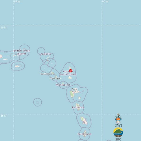
Magnitude 3.5 Earthquake Recorded North of Antigua
The UWI Seismic Research Centre (SRC) has confirmed a magnitude 3.5 earthquake that occurred at 10:57 p.m. local time on Wednesday, October 8, 2025. The seismic event was centered at latitude 17.49°N and longitude 61.77°W, with a depth of 19 kilometers. The epicenter was situated approximately 43 kilometers north-northeast of St. John’s, Antigua; 91 kilometers northeast of Brades, Montserrat; and 109 kilometers east-northeast of Basseterre, St. Kitts and Nevis. The SRC emphasized that the earthquake was automatically recorded and that further analysis may lead to revisions in its location and magnitude. Fortunately, there have been no immediate reports of damage or injuries. The region, known for its seismic activity, remains on alert as authorities continue to monitor the situation. The SRC has urged residents to stay informed and prepared for potential aftershocks. This event underscores the importance of robust seismic monitoring systems in earthquake-prone areas.