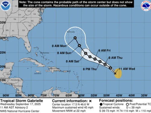
The Dominica Meteorological Service has officially announced the formation of Tropical Storm Gabrielle, which evolved from Tropical Depression 7 early Wednesday morning in the central tropical Atlantic. As of 11:00 AM, Gabrielle was positioned roughly 1,085 miles east of the northern Leeward Islands, advancing north-northwestward at a speed of 22 mph. The storm is generating maximum sustained winds of 45 mph, with gusts reaching higher velocities, and its wind fields extend up to 175 miles, predominantly east of its center. Forecast models predict a gradual shift to a northwestward to west-northwestward trajectory, accompanied by a slowdown in speed over the next few days. While significant intensification is not anticipated within the next 48 hours, gradual strengthening is expected over the weekend. The storm is projected to pass north of the northern Leeward Islands, prompting residents to stay vigilant and monitor official updates. In Dominica, unstable atmospheric conditions tied to an upper-level trough are likely to result in increased cloud cover and scattered showers over the next 12 to 24 hours. Light winds and higher daytime temperatures may further fuel cloud formation and isolated thunderstorms, particularly in the afternoon. Marine conditions are expected to remain slight to moderate in the coming days, with wave heights reaching up to 3 feet along the west coast and up to 5 feet along the east coast. However, eastern coastal waters may experience heightened wave activity, with heights nearing 8 feet and ground swells anticipated by Friday.
WEATHER (12:00 PM, Sept 17): Tropical Storm Gabrielle forms in Central Atlantic; weather system to influence local conditions