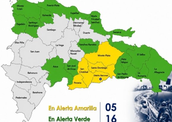
Authorities in the Dominican Republic have ramped up weather preparedness measures, expanding the yellow-level weather alert to five regions – including the capital’s National District – as an active tropical wave approaches the Caribbean nation, the Emergency Operations Center (COE) confirmed this week. A further 16 provinces remain under a lower-level green alert as forecasters track the system’s evolving impacts on local weather conditions.
The National Meteorological Office (INDOMET) reports that the tropical wave has already begun to steadily boost atmospheric moisture levels across the country, while northeasterly trade winds persist across the region. This combination of weather conditions is projected to trigger widespread downpours, scattered severe thunderstorms, and sudden strong wind gusts across much of the affected territory.
Current numerical weather prediction models forecast total rainfall accumulation between 50 and 100 millimeters across alert zones, with some isolated pockets potentially seeing even higher precipitation totals. Officials have warned that the heavy rainfall creates a elevated risk of urban flash flooding, especially in low-lying communities, along roadside drainage corridors and other major transit routes that are prone to waterlogging during intense rain events.
The five jurisdictions placed under yellow alert, the second-lowest alert tier that calls for heightened preparedness, are Santo Domingo Province, the National District, San Cristóbal, Monte Plata, and Peravia. The 16 provinces maintaining green alert status, a lower-level warning that urges general precaution, are Samaná, San José de Ocoa, San Pedro de Macorís, Sánchez Ramírez, Espaillat, Puerto Plata, Santiago Rodríguez, Valverde, Azua, El Seibo, Hato Mayor, La Altagracia, La Romana, María Trinidad Sánchez, Dajabón, and Monte Cristi.
In a public advisory, COE has urged all residents living in alert zones to remain closely tuned to official weather updates from government agencies and implement basic precautionary measures to reduce flood-related risks. Specifically, officials warned the public against attempting to cross swollen rivers, streams, or ravines with fast-moving elevated water levels, and urged people to avoid recreational use of beaches and other coastal bathing areas throughout the alert period.
For maritime activity, COE noted that unsafe sea conditions are expected along the country’s Atlantic coastline between Cabo Engaño and Cabo Francés Viejo over the coming 24 to 72 hours. Operators of small, fragile, and medium-sized vessels have been advised to avoid non-essential travel and navigate with extreme caution if they must put to sea, due to the rough sea conditions forecast tied to the tropical wave.