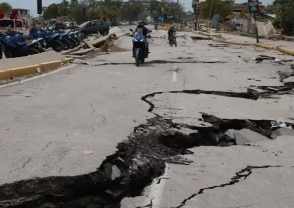
On the evening of March 24, Venezuela was hit by two powerful earthquakes within a short window, registering magnitudes 7.5 and 7.2 respectively on the Richter scale. As of the latest updates, the catastrophic seismic event has claimed more than 900 lives, left over 3,000 people injured, and left more than 50,000 residents unaccounted for across the affected regions.
The tremors, which struck just after 6:00 p.m. local time, were not limited to Venezuelan territory—shaking was clearly felt as far away as the Dominican Republic, prompting urgent questions about why the seismic activity extended across such a wide distance in the Caribbean. The epicenters of the two quakes were located near Morón, a city in Venezuela’s Carabobo state, roughly 160 to 200 kilometers from the capital Caracas. Minutes after the ground stopped shaking, local Venezuelan newspaper Hoy reached out to prominent geologist Osiris de León to break down the science behind the cross-border tremors.
De León explained that the Caribbean tectonic plate, a mostly oceanic tectonic boundary, sits between Venezuela and the Dominican Republic and extends across multiple neighboring nations in the Caribbean region. This shared geological framework means it is entirely expected for seismic activity originating in Venezuela to be felt on Dominican soil. “In terms of seismic dynamics, the 900-kilometer gap between the two countries is not nearly large enough to block seismic waves,” de León noted. Compression waves, one of the primary forms of seismic energy generated by earthquakes, can travel at speeds up to 6,000 meters per second, allowing them to propagate across most of the Caribbean basin and trigger noticeable shaking far from the earthquake’s epicenter. While de León stressed that cross-border shaking of this magnitude is “not normal, not frequent, it’s not common,” he confirmed that it remains a geologically possible outcome of large seismic events in the region.
The root cause of Venezuela’s latest major earthquakes lies in the long-standing tectonic activity along the boundary where the Caribbean Plate and the South American Plate meet. Off the northern coast of Venezuela, these two massive tectonic structures constantly grind and slide past one another, building up and releasing stress that generates sustained seismic activity along a strip stretching from Venezuela’s border with Colombia all the way to its central Caribbean coastline.
As rescue and response efforts get underway, the International Organization for Migration (IOM), a United Nations agency, has released an early impact assessment. The IOM estimates that as many as 6.76 million people across Venezuela could be affected by the destruction caused by the two quakes, with roughly two million of those people residing in the capital city of Caracas.