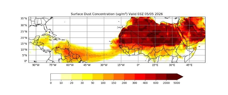
A distinct cloud of mineral dust originating from the arid Saharan Desert in North Africa is currently traversing the Atlantic Ocean, carried westward by dominant transoceanic winds. According to an official advisory issued by the Grenada Meteorological Service, this natural weather event is projected to primarily impact the southern portion of the Windward Islands, with the Caribbean nation of Grenada facing the most significant effects.
The advisory, which remains in force from Monday evening through Wednesday, May 6, projects that moderate reductions in air quality will begin across Grenada later on Monday and persist through the end of the advisory period. Analysis of real-time satellite imagery and atmospheric modeling data confirms that concentrations of Saharan dust in Grenada’s lower atmosphere will climb steadily through Monday afternoon, reaching their highest peak during the overnight hours between Monday and Tuesday. Gradual improvement in air and atmospheric conditions is forecast to begin by early Thursday morning, as the dust plume continues its westward movement away from the island.
The Grenada Meteorological Service has confirmed that it will maintain continuous, close monitoring of the plume’s trajectory and concentration levels, with updates to be issued if conditions change significantly. Two primary impacts have been highlighted for residents and visitors: first, general reductions in horizontal visibility that may affect ground transportation and small vessel navigation; second, elevated health risks for individuals with pre-existing respiratory conditions, who are advised to take appropriate preventative precautions to minimize exposure to fine particulate matter.
This report was published by NOW Grenada, which notes it is not liable for third-party contributor content, and provides a channel for users to report any inappropriate content shared on its platforms.