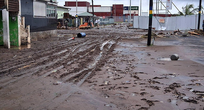
A powerful tropical wave has swept across St. Vincent and the Grenadines, unleashing heavy rainfall that caused widespread infrastructure damage and travel disruptions by early Tuesday morning. Over the 24-hour period ending at 6 a.m. local time Tuesday, the small Caribbean nation recorded a total of 130.2 millimeters (5.2 inches) of precipitation, triggering flash flooding and landslides that damaged multiple residential properties across the country, including in the capital city of Kingstown.
In response to the hazardous conditions, government officials moved quickly to adjust daily operations, announcing the immediate cancellation of all classes for Tuesday. However, contrary to a widely circulated fake notice claiming all work was suspended, senior government officials confirmed that public sector employees were still required to report to their regular duties. Senator Lavern King, who holds the information portfolio, shared the official clarification during an interview with Hot 97 FM, noting that she had coordinated directly with Public Service Minister and Deputy Prime Minister St. Clair Leacock to confirm the policy.
“For the private sector, individual employers will issue their own guidance on whether staff need to report to work, but for all public sector teams, operations are proceeding as scheduled,” King stated. She added that Prime Minister Godwin Friday was already on the ground alongside emergency assessment teams to evaluate the full scope of damage across affected regions, and that any further adjustments to the government’s operational guidance would be released promptly if conditions change.
King’s public clarification came after the National Emergency Management Organisation (NEMO) issued a formal warning about the legal consequences of spreading false disaster-related information in the country. Under the 2006 National Emergency and Disaster Management Act, intentionally spreading false disaster alerts or declarations is classified as a criminal offense, carrying penalties of up to a $5000 fine and/or one year of imprisonment. NEMO also urged the public to be particularly wary of AI-generated misleading posts, reminding residents that all official announcements about service or business closures will only be released through NEMO’s verified official communication channels.
The heavy rainfall has also forced disruptions to critical healthcare services in the hardest-hit areas. The Ministry of Health announced Tuesday that all outpatient appointments at Milton Cato Memorial Hospital (MCMH) and the Levi Latham Health Centre in Mespo have been cancelled, after floodwaters entered both healthcare facilities. Restricted visitor policies have also been implemented at MCMH’s Male Medical Ward and Paediatric Ward to protect patient safety. The health ministry advised that expectant mothers arriving in labour should proceed directly to MCMH’s Maternity B Ward, and shared a dedicated emergency contact number (456-1955) for residents requiring urgent medical assistance, noting that further updates will be shared as cleanup operations progress.
Traffic authorities have also warned motorists of widespread travel disruptions, reporting that multiple road blockages have cut off access in and out of Kingstown, as well as along stretches of road on the windward and leeward coasts of St. Vincent. In a social media advisory, the Police Force’s Traffic Branch urged drivers to use alternate routes where available, plan for extended travel times due to expected congestion and delays, and avoid unnecessary travel through affected regions if possible. Officials also reminded motorists to reduce speeds, maintain safe following distances, and remain alert for displaced pedestrians and obstacles on roadways, adding that traffic teams are actively monitoring conditions and assisting with movement through impacted areas.
As of 6 a.m. Tuesday, the SVG Meteorological Services reported that the tropical wave was still impacting the nation, with forecasts calling for continued cloudy to overcast conditions with pockets of moderate to heavy rain, scattered thunderstorms through midday, before tapering off to mostly cloudy skies with only a few showers. Forecasters have continued to urge residents and drivers in landslide and flash flood-prone areas, as well as communities located near rivers and streams, to remain on high alert.
Looking ahead at the multi-day forecast, conditions are expected to stabilize gradually. A few residual passing showers are possible Tuesday evening as the tail of the tropical wave passes through the region. On Wednesday, light winds are forecast to bring warmer temperatures with occasional passing showers, while Thursday is expected to see partly cloudy skies across the country.