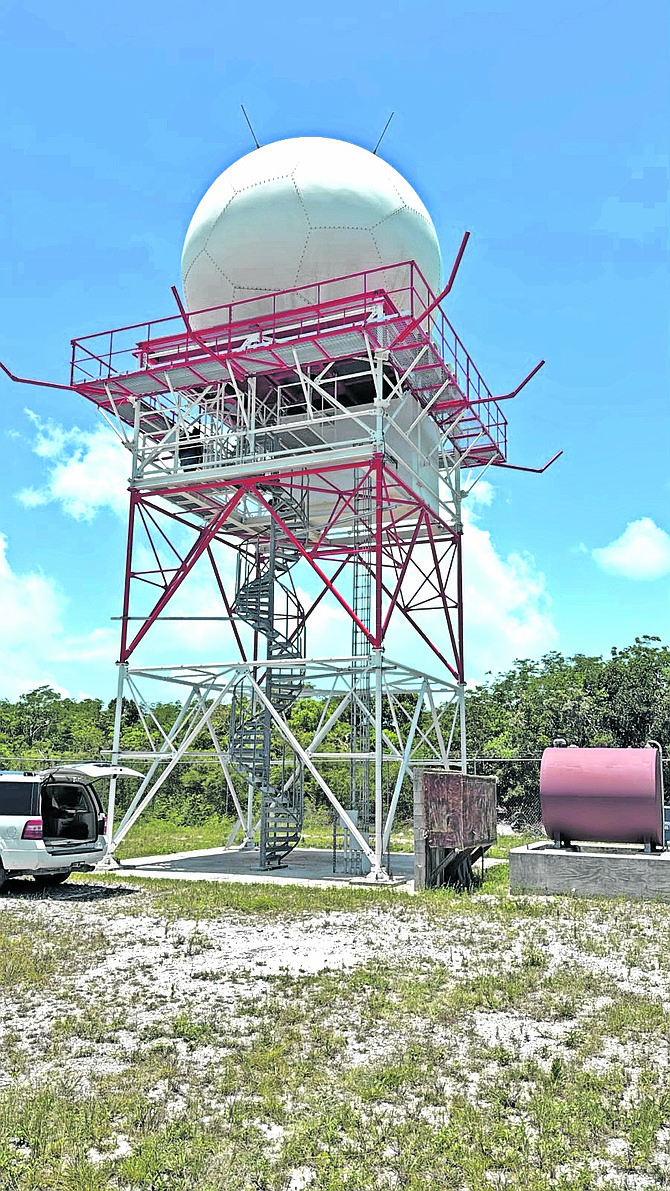
A landmark moment for meteorological infrastructure in The Bahamas has been reached this week, as the entire four-unit fleet of the country’s C-Band National Weather Radars began simultaneous operation — a first in the nation’s history. This long-awaited milestone was made possible after the Mayaguana radar, which was originally installed back in March 2021, was powered up for the first time, completing a contiguous radar network that covers the entire Bahamian archipelago and extends its monitoring reach toward the neighboring Turks and Caicos Islands.
Sited in the southeastern portion of The Bahamas, the Mayaguana radar fills a critical gap in the national weather monitoring system. Its activation by the Bahamas Aviation Climate & Severe Weather Network (BACSWN) unlocks the full capabilities of the integrated four-radar system, bringing the years-long modernization project one major step closer to completion. The breakthrough comes just months after BACSWN signed a $427 million Heads of Agreement with the Bahamian government on May 7, 2025, through which the organization committed to a sweeping expansion of weather and radar surveillance across the entire country.
Patrick Rollins, president and chief executive officer of BACSWN, publicly thanked his team for their relentless work to bring the project to fruition, and also recognized the substantial time, funding, and technical support contributed by Bahamas Power and Light (BPL) throughout the development process. The four C-Band radars, strategically positioned across New Providence, Abaco, Long Island, and Mayaguana to provide overlapping coverage, were first deployed as a core component of a roughly $20 million national weather radar modernization initiative launched by the government back in 2017, with construction and installation carried out by global meteorological technology firm Vaisala.
Looking ahead, project leaders have set their next target: restoring and integrating the legacy EEC S-Band weather radar located on Ragged Island into the new national network. Once that unit is returned to full operational service, it will add further resilience to the country’s radar infrastructure and fill the last remaining coverage gap to complement the four active C-Band systems already in place.
Michael Strachan, Chief Operating Officer of BACSWN, explained that the expanded, fully connected network will allow meteorological forecasters to cross-reference radar observations with dozens of other complementary meteorological data streams. This integration will produce a far broader, more uninterrupted picture of precipitation, severe thunderstorms, and other high-impact weather events as they develop, traverse the islands, or approach the Bahamian archipelago from the Atlantic.
The timing of this historic activation carries particular urgency, as the annual Atlantic hurricane season is already underway. The enhanced, contiguous radar coverage will drastically improve The Bahamas’ capacity to monitor developing tropical systems and severe thunderstorms, detect rapidly shifting weather conditions, and deliver real-time data to underpin more accurate forecasting, faster public warnings, and more effective emergency preparedness actions. For a low-lying island nation that faces repeated hurricane threats, this upgrade represents a critical improvement to public safety infrastructure.
According to BACSWN, the newly completed radar network will serve as the foundation for a much broader, next-generation weather and aviation surveillance ecosystem that will integrate Raytheon’s cutting-edge multi-function phased-array radar technology, advanced electro-optical sensors, and a suite of other modern monitoring systems. The organization is also partnering with the U.S. National Oceanic and Atmospheric Administration (NOAA) to integrate the Advanced Weather Interactive Processing System (AWIPS), the same operational forecasting and weather data aggregation platform used by the U.S. National Weather Service, NOAA, and the U.S. National Hurricane Center.
Once fully integrated, AWIPS will allow BACSWN’s aviation meteorologists to combine radar observations with satellite imagery, ground-based surface readings, numerical weather prediction models, lightning detection data, and dozens of other meteorological data inputs all within a single unified operational interface, streamlining forecasting workflows and reducing delays in critical warning dissemination.
BACSWN also noted that its ongoing development of the proprietary WxSenseNet™ system, its strategic partnership with Israeli satellite weather technology firm Tomorrow.io, and ongoing collaborative research and development efforts with the U.S. National Center for Atmospheric Research (NCAR) and NOAA will continue to expand and refine the country’s national weather monitoring capabilities in the coming years.
The benefits of this new network extend far beyond just hurricane preparedness. Improved radar coverage and integrated, accessible meteorological data will deliver enhanced situational awareness for a wide range of stakeholders, including commercial and general aviation, commercial marine shipping and fishing operations, emergency management agencies, national and local government bodies, private sector businesses, and local communities across the archipelago.
For BACSWN, the activation of all four C-Band radars marks a critical milestone on the path to fully modernizing The Bahamas’ national weather infrastructure, improving the nation’s ability to deliver timely, accurate weather intelligence, boost aviation safety across the country’s airports and airspace, and strengthen resilience to hurricanes and other severe weather events.
Itai Zlotnik, co-founder of Tomorrow.io, emphasized the transformative nature of the project. “We built Tomorrow.io to own the whole chain: satellites that sense the atmosphere, models that run on what they measure, and software that turns both into a decision,” Zlotnik explained. “A national aviation weather centre used to take a decade of capital to build. The Bahamas is skipping that and building the first next-generation meteorological watch office from the ground up, for a strategically located nation encompassing 173,000 sq miles – 95 percent ocean. That only works with a partner as ambitious as the idea, and BACSWN is that partner. Working with them has been a privilege. They knew exactly what the country needed, held every partner at the table to a world-class standard, including us, and pushed us to be better. It is the kind of partnership we hope for on every programme and rarely get. In Nassau, their sensor network anchors the ground, our satellites observe the sky, and our models turn every observation into a decision: hold the approach, reopen the runway. Pilots, controllers and the communities they serve will have weather intelligence most of the world does not have yet.”