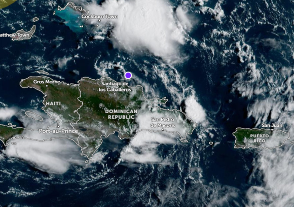
Residents of the Dominican Republic are bracing for a period of hazardous weather as an active atmospheric disturbance positioned just north of the country tracks toward the west-northwest, top meteorologist Jean Suriel has confirmed. In an official weather advisory, Suriel outlined that over the next 6 to 12 hours, the island nation will see a sharp uptick in storm activity, including intense downpours, sudden wind gusts, and rolling thunderstorms across most of the territory.
The greatest immediate risk highlighted by Suriel is the growing threat of flash flooding, which is expected to escalate through this afternoon. Communities located in low-lying, vulnerable zones and densely populated urban areas are at particular risk, as heavy rainfall can accumulate rapidly on saturated or impermeable urban terrain, overwhelming drainage systems in a matter of minutes. Moderate to extreme rainfall will extend across the majority of the Dominican Republic through tonight, with forecasters noting that full urban flooding is a distinct possibility across key regions including Cibao, the country’s southern zone, and the southeastern corridor.
Beyond the immediate storm threat, the National Meteorological Office is tracking four separate atmospheric systems across the entire Atlantic basin, two of which carry a moderate to high chance of strengthening into organized tropical systems over the coming days. The four systems currently under close observation include: a second disturbance forming over the Gulf of Mexico, which forecasters say is likely to develop into a named tropical depression in the near term; the active disturbance north of the Dominican Republic, which is linked to the already documented Tropical Wave 43; Tropical Wave 45, currently positioned across the central Atlantic and projected to enter the Caribbean region near the Dominican Republic by Thursday; and the most recently identified Tropical Wave 46, located in the far eastern Atlantic, which is on track to approach the island’s vicinity by Sunday.
In closing his advisory, Suriel issued a clear call to action for all Dominican residents, urging communities across the country to stay vigilant and monitor updated official weather forecasts continuously over the coming hours. He emphasized that populations living in areas with a history of flash flooding should prioritize preparedness, as weather models consistently point to increasing storm intensity and rainfall accumulation through the rest of the day.