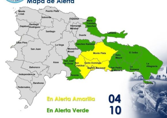
The Caribbean nation of the Dominican Republic has implemented early warning measures across multiple key regions this week, as an approaching active tropical wave drives increased rainfall and unstable atmospheric conditions across the country. In an official announcement from the capital Santo Domingo, the country’s Emergency Operations Center (known locally by its Spanish acronym COE) issued a yellow alert for four high-population areas, while keeping 10 additional provinces under a lower-level green alert as meteorologists track the system’s progress.
National weather service the National Meteorological Office (INDOMET) reports that the tropical wave is steadily pushing higher levels of moisture across the Dominican Republic’s territory, paired with persistent northeasterly winds. This combination has created ideal conditions for intense downpours, sudden thunderstorm outbreaks, and possible strong wind gusts across the alerted regions, with forecasts calling for continued unstable weather through the system’s passage.
The four areas placed under yellow alert, the second-highest warning tier indicating elevated risk, are Santo Domingo Province, the National District (the country’s capital core), San Cristóbal, and Monte Plata. The 10 provinces under green alert, a lower-level advisory calling for preparedness, are Samaná, San Pedro de Macorís, Hato Mayor, La Romana, El Seibo, La Altagracia, Sánchez Ramírez, San José de Ocoa, Peravia and María Trinidad Sánchez.
Emergency management officials have issued clear public safety guidance for residents in all impacted zones. The COE strongly urged local populations to remain vigilant, and specifically warned against attempting to cross rivers, streams, and ravines, where water levels have already risen sharply due to sustained rainfall. Authorities also added that the public should avoid all recreational use of beaches, rivers, and other open swimming areas across all alerted provinces, with the ban set to remain in place until weather conditions stabilize and are deemed safe.
All alert measures are set to stay active as emergency and meteorological teams continue round-the-clock monitoring of the tropical wave’s evolution. Officials are closely tracking the system to detect any increase in intensity or shift in trajectory that could lead to heavier rainfall or more severe thunderstorm activity across other parts of the country.