As Venezuela remains under a state of emergency four days after a destructive double earthquake killed more than 900 people, a leading Dominican geologist has issued a stark analysis of what a similar seismic event could mean for his Caribbean nation. In a recent interview on the radio program *La Universidad de la Calle (LA UCA)* hosted by Brea Frank, geologist Osiris de León outlined that the scale of damage from any major earthquake depends on two core factors: the proximity of active geological faults to populated areas, and the composition of local soil.
De León drew a direct comparison between the recent Venezuelan disaster and the Dominican Republic’s seismic risk profile, noting one critical difference: the fault that triggered the Venezuelan quake runs directly through the country’s most densely populated coastal corridor. “In Venezuela’s case, the fault responsible for the tremor cuts straight through Maiquetía airport, and runs straight through the populated communities of Macuto and La Guaira — that concentration of infrastructure and people directly above the fault is what drove such extreme destruction,” de León explained. “In the Dominican Republic, our most active faults are located much farther from major population centers.”
The geologist highlighted that the closest active fault to the capital city of Santo Domingo sits 70 kilometers off the southern coast, while the fault nearest to the northern city of Puerto Plata is roughly 50 kilometers inland from the urban core. This greater distance, he noted, naturally weakens seismic waves as they travel, reducing the potential damage to populated areas compared to the Venezuelan event. But distance alone is not enough to eliminate catastrophic risk, de León warned.
The second critical factor, he explained, is the type of soil where seismic waves make landfall. Soft, organic soils — common across the Dominican Republic’s fertile Cibao Valley — amplify seismic activity rather than absorbing it. Historical records bear this out: the massive 1562 earthquake on December 2 completely destroyed the Cibao Valley cities of Santiago and La Vega. This pattern could repeat if a major quake strikes near the northern coast today, de León said.
“If an earthquake of the same magnitude as Venezuela’s recent double event hits off the coast near Puerto Plata, Luperón, or Sosúa, the Cibao region could see damage just as bad — or even worse — than what Venezuela is currently facing,” he cautioned. The warning extends to multiple major Cibao communities including Santiago, La Vega, Bonao, San Francisco de Macorís, Moca, Villa Tapia, and Tenares, all of which are built on rich black organic soils ideal for agriculture but extremely dangerous for construction during seismic events. “These soils amplify the entire seismic spectrum, turning a moderate tremor into a catastrophic event for infrastructure above,” de León added.
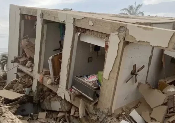
Across the border in Venezuela, the aftermath of the mid-week double quake continues to unfold. Saturday marked the fourth consecutive day of the national state of emergency declared after the disaster. As of the latest official update, the death toll from the quake has reached 920, with more than 3,300 people injured. Rescue teams from nine countries have deployed to the impacted region to support search operations for survivors and recovery efforts for victims.