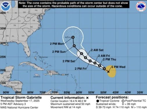
Tropical Storm Gabrielle is steadily progressing toward the northern Leeward Islands, currently moving northwest at a reduced speed of 14 mph. As of 5:00 PM, the storm’s center was positioned near latitude 19.4°N and longitude 48.0°W, approximately 990 miles east of the island chain. The storm’s maximum sustained winds have slightly increased to 50 mph, with stronger gusts extending up to 205 miles east of its core. Meteorologists predict Gabrielle will maintain its current intensity over the next 48 hours, with potential slow intensification over the weekend. The storm is expected to pass north of the northern Leeward Islands during this period, prompting authorities to advise residents to remain vigilant and stay updated with official weather bulletins. Concurrently, unstable atmospheric conditions associated with an upper-level trough are anticipated to bring intermittent cloudiness and scattered showers to Dominica over the next 12 to 24 hours. Light winds and elevated daytime temperatures may exacerbate these conditions, increasing the likelihood of isolated thunderstorms in the afternoon. Marine conditions remain relatively calm for now, with wave heights reaching up to 3 feet along the west coast and up to 5 feet on the east. However, eastern coastal waters are forecast to experience a surge in wave activity by Friday, with swells potentially climbing to near 8 feet and the possibility of ground swells. Residents, particularly those in coastal and flood-prone areas, are urged to exercise caution and stay informed through official weather updates.
WEATHER (6:00 PM, Sept 17): Tropical Storm Gabrielle slows as it tracks toward northern Leeward Islands