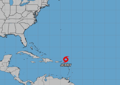
BRIDGETOWN, Barbados (CMC) — Tropical Storm Jerry, the 10th named storm of the 2025 Atlantic Hurricane Season, is projected to pass north of the Leeward Islands on Friday morning before moving away later in the day. The Miami-based National Hurricane Center (NHC) has issued warnings for residents to prepare for potential flash flooding caused by heavy rainfall. Currently located approximately 80 miles north-northeast of the Northern Leeward Islands, Jerry boasts maximum sustained winds of 50 mph. A tropical storm warning is active for St Barthelemy, St Martin, Sint Maarten, Guadeloupe, and adjacent islands, while a tropical storm watch remains in place for Saba and St Eustatius. The government of Antigua and Barbuda has lifted warnings for Barbuda, Anguilla, Antigua, St Kitts, Nevis, and Montserrat. Jerry is moving northwest at 17 mph, with a northward turn expected tonight into Saturday, followed by a north-northeast trajectory through the weekend. The NHC forecasts four to six inches of rain for Barbuda and two to four inches for other Leeward and Virgin Islands, raising concerns of flash flooding in urban and steep terrain areas. Additionally, swells generated by Jerry are creating life-threatening surf and rip current conditions across the region, with impacts expected to spread to the Greater Antilles on Friday.
Flash flooding threat as Tropical Storm Jerry makes its way across the Leeward Islands