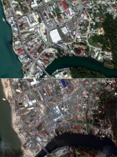
KINGSTON, Jamaica — The Caribbean island of Jamaica endured catastrophic devastation as Hurricane Melissa, a Category 5 storm, made landfall on Tuesday. With relentless winds and torrential rains, the hurricane has been declared the most powerful storm ever to strike the nation. The aftermath has left four fatalities, obliterated homes, crippled critical infrastructure, and severed road networks, plunging the country into a daunting recovery process. Satellite images captured by Vantor starkly illustrate the scale of destruction in key communities such as Black River, New Hope, White House, and Montego Bay. These before-and-after visuals reveal entire neighborhoods reduced to rubble, once-thriving areas now unrecognizable. The Jamaican government and international aid organizations are mobilizing emergency response efforts, but the road to recovery is expected to be long and arduous. Hurricane Melissa’s unprecedented intensity has raised concerns about the increasing frequency and severity of extreme weather events in the region, underscoring the urgent need for climate resilience strategies.
#MelissaAftermath: Before and after images show striking impact of Hurricane Melissa on Jamaica’s landscape