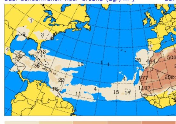
This coming Sunday, the Dominican Republic will see a significant shift in its weather patterns, as a dry air mass carrying moderate levels of Saharan dust moves into the region, bringing a sharp drop in the likelihood of widespread rain across most of the country.
While the preceding tropical wave continues to drift away from the nation, an upper-level trough will remain anchored over the area. Combined with localized geographic effects, this system will drive increased cloud buildup over the Central Mountain Range and the country’s northeast, covering provinces including Espaillat, Hermanas Mirabal, La Vega, Monseñor Nouel, southern Santiago, and Santiago Rodríguez. Meteorologists predict scattered local afternoon downpours in these zones, with a chance of accompanying thunderstorms and sudden wind gusts.
In a key update, the National Forecast Center under the Dominican Institute of Meteorology (Indomet) has ended the incremental weather alert system that was previously in place for multiple provinces, even as low-level risks of urban flooding persist in those areas.
The arrival of Saharan dust, paired with the typical warm conditions of this time of year, will leave most of the country experiencing unseasonably hot temperatures. In response, Indomet has issued ongoing public guidance to help residents beat the heat: stay consistently hydrated, opt for light-colored, loose-fitting clothing, seek out cool, well-ventilated spaces, and avoid prolonged exposure to direct sunlight between the peak heating hours of 11 a.m. and 4 p.m.
Officials are urging additional care for children, older adults, and pregnant people, as these groups are the most susceptible to heat-related illness and adverse health effects.
Breaking down forecasts for specific regions, the Greater Santo Domingo area can expect a mix of occasional cloud breaks and periods of overcast skies. Temperatures will range from a low of 23°C (73°F) to 25°C (77°F) overnight and in the early morning, climbing to a high between 32°C (90°F) and 34°C (93°F) during the daytime.
Looking ahead to Monday, isolated showers are projected for coastal regions adjacent to the Caribbean and along the northeast coast in the early hours of the day. Most other parts of the country will stay partly cloudy through the morning. While afternoon conditions will remain fair across many regions, the combination of the lingering trough, regional wind patterns, and local effects will increase cloud cover over towns in the southeastern, northeastern, Central Mountain Range, and border regions. Local downpours, possible thunderstorms, and gusty winds are forecast for these zones, with all unstable weather expected to die down by nightfall.